

Today’s parkup features a gorgeous seaside cliff view with a long, gentle grassy slope up towards tomorrows adventure. The day dawned unusually sunny but with the usual stiff breeze. Along the cliff we found a blowhole covered with a much appreciated huge steel grate to keep us funseekers from falling a hundred or so feet down into the ocean.

The ocean views only improved as we climbed the hill along this craggy coast.


Reaching a plateau, we came upon an otherworldly area that had what can only be described as strange puffy pockets of grassy turf.

So springy, it was as though they were filled with foam rubber or air pockets, making it extremely difficult to walk on.

Hilking through this area one feels like a drunken sailor or as if walking through the funhouse at an amusement park. Turns out the pockets are filled with spongy sphagnum moss which absorbs quite a bit of water, and is not the most secure feeling when walking on the edge of a cliff in gusty wind but a thrillseeker’s got to do what a thrillseeker’s got to do.

We’ve seen “Eire 80” spelled out in huge letters and numbers, laid out on Malin Head, also a conspicuous headland, and we’re told they’re to inform airplanes that Ireland is neutral, they are about to enter Irish airspace and — I’m going to make a leap here — it also means YOU ARE HERE at “Eire 64.” We have no drone. Use your imagination.

What differentiates this sea stack from others we’ve seen is that the ruins of an ancient residence still exists on the surface of the sea pillar.


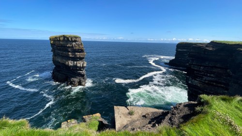
As part of its fortifications, a natural land bridge once spanned the 80 meters to mainland Downpatrick Head. In 1393 a hurricane washed the land bridge away falling the 50 meters down into the North Atlantic leaving families stranded on the new sea pillar island. Eventually they had to be evacuated, rescued using ship’s ropes. Of course the Irish being Irish there are always going to be more than a few myths or folk tales about how the land bridge fell: mythical ogres and such. Even St. Patrick, livid that he couldn’t convert Chief Crom Dubh to Christianity, clove the land bridge with his shepherd’s crook and left him to starve to death on the newly created “island.” A believe-or-die kind of proposition.

No, I agree he doesn’t look that fierce, really almost meek, but I suppose we all have a dark side.
Continuing to the end of Downpatrick Head we find more religious zeal in the form of a sport I call high altitude fishing while clinging to cliffs in a stiff breeze, at a vertigo-inducing height.


Retracing our path back down the hill we found another major blowhole fed with a 400 foot tunnel from the ocean.


It seems that during the 1798 rebellion 25 rebels hid in this tunnel while the British scoured the area. Unfortunately the rebels were trapped and drowned at high tide.
With that grizzly scene replaying through my mind we reached Escape Velocity and I noticed a brilliant flash of light at the top of the mountain across the bay, the same mountain we will cross tomorrow. I’d seen it before. It reminded me of the bright reflection of sunlight that sometimes you see off a car mirror or the glint off an airplane window, but this was randomly flashing brilliantly from the same spot. I focused the binoculars on the source and, if I didn’t know any better, I’d guess that sticking up over the top of the mountain was a pyramid! Turns out it is. We had blunderstumbled onto the welcome center for the world famous (but previously unknown to us) Ceide Fields complex.

At 5,500 years old, Ceide Fields is oldest known field system in the world. The site is queued up for admission to UNESCO World Heritage status.

Stone walls delineated every field for miles around the mountainside indicating a complex farming community. Bog began to encroach on the fields and eventually covered most of it. In these local conditions the bog, usually very slow growing, covered the site at the rate of about a meter per thousand years. Eventually the site was abandoned and forgotten until a farmer in the 1930’s discovered a buried stone wall while cutting turf.
Once again no one knows why or exactly when the fields were abandoned but the only way to find the stone walls now is by probing the turf with a long metal rod until they hit the top of a wall. In this way scientists are mapping the fields without disturbing the landscape.


Get a deeper dive into Ceide Fields here.
