The Journey itself is Home

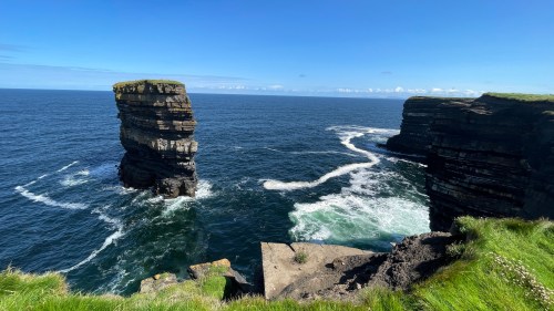
Morning found a handful of us RVers huddled together, lost in a truly massive, mostly paved parking lot. We have come to the iconic Cliffs of Moher and we are huddled together because it’s the only semi level spot in the whole damn car park.

It’s overcast, gloomy, and rainy and any thoughts of hiking are laughable at this point. The situation is that it’s quite a hike just to get to the start of the hike. Eventually we deemed it passable and we gathered our resources if not our boots and trudged up to the interesting looking visitor center.

At the cliffs the path bifurcates and we chose the path to the right, up towards O’Brian’s Tower (1835), sitting like a crown on top of the hill.

As we descended the hill we had a great view of the cliffs as they wrap around the bay to the left.

The trail constantly rises, sometimes narrow, sometimes wider, but always relentlessly climbing.

I couldn’t help but notice they had moved the trail back from the cliff edge a disconcerting dozen feet or so.

Eventually we reached what felt like the high point, although it looks like one of those Irish hikes that continue on for many more miles along the coast.

Reluctantly we headed back down.

Footsore and tired, we made it back to Escape Velocity but there was no rest for your aimless wanderers and we had just enough time to make it to our next parkup.

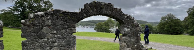
What a jewel awaited us at this tiny car park.

We knew there would be some sort of ruin here but I never gave it much thought, thinking it’s probably closed anyway. Yeah, I know you’re thinking this is a possible rule #2 violation (Don’t get jaded.) But the more I studied this tower the more excited I became. And as it turns out, it’s open and free to explore.

Carrigafoyle Castle was constructed by Connor Laith O’Connor in the 1490’s on a large outcropping rock at the mouth of the Shannon. It was thought of as the Guardian of the Shannon due to its strong strategic location.

Other times the owners were thought of as the taxman because of their habit of sailing out to intercept shipping on its way up to Limerick and demanding a handsome percentage of the cargo. The ships were easily spotted from the 98 foot tall tower.

The unconventional choice of using flat slabs of flagstone was because in the 1490s it was thought to be impenetrable by the conventional weapons of the time.

Technology marches on and by 1580 during the Easter siege of the castle, the Brits had the answer and used high powered cannons. They fired from the hills behind the castle and blew that fearsome hole high in the tower which collapsed the wall, crushing most of the rebels beneath. Any survivors were dispatched as per the rules.

The double arches supporting the roof are probably the only reason the tower still stands.

It takes 104 steps up the spectacular spiral staircase to reach the atrium at the top.

The view from the top reminded us that our tendency to wander with no set destination sometimes brings surprising rewards. And it’s why we coddiwomple, travel for the sheer pleasure of the journey.

2 Comments

Filed under Uncategorized

Beginnings of the Burren

Personally I wouldn’t go far out of my way to see something more stark than where I already am, but you know, in the interest of familial peace I acquiesced. Besides, somehow the navigator was guiding us right past a small pull off of great historical import. I managed to drive right past but quickly got Escape Velocity turned around and we immediately saw a nicely walled in, uh, front yard for lack of any accurate knowledge.

Wandering around through the woods we found the lintelled stone and mortared gateway to Cahermore.

Apparently it started as a medieval fort sometime between 500 to 1170 AD and by 1308 it was a wealthy family’s homestead featuring three outer stone rings around a central group of buildings.

Off in the distance in most of these photos you can see the heart of the hills of the Burren, showing the effect of multiple ice ages that shaved clean the hills leaving naked rock. And that’s where we’re headed.

The Burren is a unique glaciokarst landscape designated a UNESCO Geopark. If you want to know about the geological and human history of the region you can read more here or here.

We’d been winding our way uphill but now the climb into the mountains started in earnest. Finally we broached the tree line and found a place to spend the night here on the side of the mountain. Just us and the rocks.

It’s a little nippy up here and without much to stop it, the wind is unrelenting.

After a cold and bumpy night we headed out with purpose. Our mission is a visit to Poulnabrone-The Portal Tomb, where it’s been known to get quite crowded so we thought a morning arrival would be best. We found lots of other rock fans but it’s a large site and it can absorb lots of funseekers.

Built on top of an oval shaped cairn of loose stone, the tomb was begun in the Neolithic period some time around 4200 BC. When it was first excavated in 1986 the remains of 33 people were found interred here.

We just heard two tour buses pull into the parking lot so that makes it about time to go.

Our parkup tonight will be a commercial affair that we’re not entirely sure we’re even allowed into, but what would it be if you didn’t try? You have to try.

2 Comments

Filed under Uncategorized

City life

We mentioned before that it can be challenging to visit cities where motorhomes are discouraged or safe parking is hard to find. We heard about a park ‘n’ ride outside Galway and took advantage of the opportunity to leave the van in the company of others of its kind while we took the train to the city.

For once it didn’t rain and Galway was a delight, colorful, artsy, often whimsical.

We stopped in the visitor’s center for a map and a walking guide but we made no attempt to see all the sights. It was fun just to share the joy of a dry day with fellow tourists.

Galway embraces the new and modern but celebrates its history, too. Here’s a look at the original castle walls under the floor of the Aran sweater market.

We tried following our walking tour map but there were too many distractions to keep us on track.

Ah! A cheese shop! Maybe we can get something besides cheddar? But no, the shop was closed and we could only peer longingly through the door at what might have been a very big sale for the proprietors.

I don’t play chess and I don’t collect anything, but if I did I’d consider chess sets. They always catch my eye wherever we go and these are particularly fanciful.

By the time we left the park it was well past lunch time. Jack couldn’t pass up the Irish stew.

We finished the day with a visit to the museum and loved seeing these posters of Irish musicians.

I wish we could visit more cities as easily as this. One quick stop on the train and we were back home again. It looks like the bad weather is behind us. Maybe we’ll have summer after all.

Leave a Comment

Filed under Uncategorized

Up and down, around and around

After a day in a crush of tourists we were keen for some quiet time, and we followed the coastline looking for a small harbor or disused pier. The rain had swelled the waterways, large and small, and we followed this stream to the shore.

Despite the volume of water rushing to the sea it was low tide and the few boats in the harbor rested on their keels.

The cozy little town of Spiddal lured us with charming traditional buildings and a pretty little library.

As usual, the propane ran out in the middle of making coffee and while it was raining. After many years of swapping propane tanks Jack’s become a speed demon at the tank changeover.

Spiddal lured me for another reason, a labyrinth. My sister introduced me to labyrinth walking back on Block Island, Rhode Island, and I’ve been keeping my eyes out for others ever since. When I spied this one on the map a few months ago I marked it and hoped our route would take us close enough for a stop.

While Jack napped I slowly walked the small labyrinth and appreciated the changing views from the churchyard and out to the sea.

The pathways were narrow, little more than a foot’s width, and just following the twists and turns amounted to a meditation in itself.

My focus alternated between the closeup and the long shot, and for the twenty minutes or so that I walked I felt at peace.

I think if we ever find ourselves living in a house with a garden I might build a labyrinth. Pretty to look at, and a beautiful way to meditate.

This labyrinth is nearly hidden behind a church and next to the graveyard. I think the setting epitomizes the Irish landscape: a church, a garden, and the sea.

2 Comments

Filed under Uncategorized

That’s our story and we’re sticking to it

To be honest, after the Achill Island debacle I’m a little surprised to be sitting here in Escape Velocity waiting, on a blustery day, for a ferry to another Irish island. The plan is to hire bicycles to explore the small island. We can feel the motion of the ferry change, rising to the ocean swell as we leave the protected bay, or lough, as the Irish seem to call anything with water in it. It’s so familiar, like coming home for this old sailor.

I’ve never felt so popular walking down the long pier toward Inishmore Island.

It seemed that the whole island turned out to welcome and pitch their wares to their new best friends, like a pop-up carnival of balloons, bus tours, cotton candy, horse drawn buggy tours, hotdogs, and guided bike tours with every permutation imaginable.

By the time we reached land our sales resistance was at a dangerously low ebb and a bemused but whimsical older gent smiled and said, “Would you like to sit down in my shiny new Mercedes minibus?” Why yes, we would. It was far too windy for bike riding. That’s our story and we’re sticking to it.

Soon we were on our way, just one happy minibus load of adventurous funseekers. It didn’t take long before it became obvious that the impossibly narrow roads were choked with tourists, backpackers, and optimistic bike riders, pushing their bikes in the fresh breeze. If there weren’t any serious injuries that day I would call it an act of divine serendipity. I confess that our whimsical driver seemed to take all this madness in stride. I was impressed with his wheel prowess. Turns out we were slowly weaving our way between the high tight stone walls, pinching in on both sides of the road, toward Fort Dun Alonghasa, built in the 1,100s BC on top of a high promontory sea cliff.

Like all high value venues the path starts out easy enough but as soon as you’re not paying attention bam, you’re crawling up over rocks at a ridiculous angle.

I’m sure that 3,500 years ago the road up to the fort made sense but let’s just agree that in the last 3,500 years some deterioration may have occurred.

Marce found a fast track around the worst

The queue, laboring slowly up the long hill began to take on the feel of a deep breathing religious procession or pilgrimage of penance.

It’s funny but I never had that thrilling feeling of standing where ancient man has stood. I don’t know, it might just be oxygen deprivation.

The original dry stone defensive ring is D-shaped and contains quite a large area.

Spectacular views from the fort.

Well we don’t want to turn Mr. Whimsy’s smile into a frown now do we? We have very little time for lunch so it’s time for our descent.

Don’t know how I missed this explosive cairn creation on the way to the fort.

This tin whistle busker was good enough that for a moment I could forget about my sore feet

You know how there’s aways someone on a tour bus that can’t seem to get back to the bus on time? Well this time it was Yours Truly but I have to admit the shepherd’s pie I had for lunch was well worth the dirty looks our fellow happy passengers gave us as we clambered aboard a few minutes tardy.

Soon we found ourselves again squeezing between the impossibly tight stone walls in search of a venue called “The Abbey.” This is Ireland, there’s always an abbey. Driving around the island it’s easy to imagine a tough rocky life.

There were small plots of land, mostly rocks and the odd patch of grass, delineated by dry stone walls with random gaps to, they claim, bleed off wind pressure.

It’s a popular stop and Mr. Whimsy had a spot of bother weaseling the big van into what passes as a proper parking spot here on Inishmore Island. Down below us was, more or less, a beautiful 15th century abbey.

By this point our driver’s wry smile was missing and all we got was “Gotta go, let’s get in the van.”

We passed a supposedly typical Inishmore homestead built for “Man of Aran,” a 1934 film by Robert Flaherty about pre-modern life on the island. It was a landmark (and somewhat controversial) film, and if you’ve got the time it’s well worth watching here.

Back in town we joined the throngs admiring the classic fisherman’s sweaters and resisted the temptation to buy. Where in a campervan would we fit one, let alone two?

We spent our last moments on Inishmore with coffee and cake and wondered about the changes a place as beautiful and as tough as this island would make in your life.

On the way back to the ferry the harbor was at low tide and that changes everything.

Leave a Comment

Filed under Uncategorized

Pier to pier

An unfamiliar sensation woke me shortly after 6:30am. It was the sun, not seen for days and certainly not in the morning when the warming rays make it so much easier to jump out of bed. And jump I did, throwing on my clothes as quickly as I could, because if there’s one thing I’ve learned about Ireland it’s that you don’t waste a minute of good weather, for surely the gods could change their minds at any moment and it’s back to the drizzle and damp. Or lately, pelting downpours and ferocious wind.

Escape Velocity parked alongside the sea wall, sheltered from the wind.

I happily walked Bunowen Pier snapping photos in the morning light until the dark clouds rolled in and chased me back to the van as the rain resumed in earnest.

It’s laundry day, and we drove about an hour in the gloom along the coast to an outdoor launderette. We love these conveniences where we can park right beside the machines. It’s almost like doing laundry in a house; no schlepping involved and the clothes go right back in the closet.

The rain stopped unexpectedly while we navigated another of Ireland’s one-lane stonewall-lined roads toward another quiet pier at the all but abandoned Cartron Harbour.

We’re always mindful that we aren’t a nuisance to local fisherman, so I asked the gentleman getting out of his car if he thought it was okay if we stayed the night. He not only assured us we’re fine on the pier, but he regaled us with local lore and shared his photos of the fine fish he caught in these parts. We hope we ooh’d and aah’d appropriately.

Our friend’s brother returned from picking blackberries along the shoreline and wanted to take a closer look at Escape Velocity. We’ve learned during our various journeys that the freedom of self-contained travel with no set schedule or destination is a dream shared by many. We’re always happy to evangelize our chosen lifestyle.

After Tom and John went home we put on our hiking shoes and set off along the rocky path around the point, grateful for the break in the weather.

We wondered when this rock wall was built and how they managed to move and place these giant boulders.

When we turned the corner we could see the Aran Islands on the horizon, just as John told us we would.

Escape Velocity is a speck in the middle of the picture.

Jack returned home while I tramped through the brambles picking berries for tomorrow’s breakfast.

We expect rain again soon and throughout the night, along with high winds. We’ll have a cup of tea and watch the tide come and go and come again.

1 Comment

Filed under Uncategorized

Mayo with mustard

Long ago, we mentioned to an Irish friend that we planned time in County Mayo. “There’s not much there,” he warned.

We beg to differ. After spending more time here than expected, thwarted by the weather and waiting for the parish priest to return, we’ve come to appreciate the varied landscape and the way of life.

We take every blue sky opportunity between storms to drive the back roads and see what we can see. One day we watched as a farmer trained his sheep dogs. Amazing herders, they are.

Turf is still used for fuel in many places, although there are new regulations underway to ban the burning of polluting solid fuels like coal, wood and peat briquettes, and new houses are built without chimneys. Turf cutting is also being banned to halt the destruction of the fragile environment and because newer mechanical methods of cutting reduces the carbon sink properties of the bog. Nevertheless, we see turf drying wherever we go.

Mayo is flat as a pancake in parts and quite hilly in others and on dry days we find the landscape breathtaking.

As usual, we haven’t done any planning or research so as we crossed into County Galway this stately building took us by surprise and precipitated a quick detour.

It’s Kylemore Abbey, home to an order of Benedictine nuns. We didn’t visit but stayed long enough on the grounds to appreciate how beautifully the building nestles into the forest at the foot of the mountain.

The clouds were rolling in and we knew there was a storm coming. We wanted to fit one more stop into our day before we sought shelter.

I had spied this food truck on the map and if I know my man, I know he’ll be pretty excited about a crab sandwich. I assumed there’d be nothing for me, but luckily there’s another truck across the car park with delicious spicy roast sweet potato tacos. Win-win.

We would love to have stayed at that pretty place overnight but it wasn’t permitted so we dashed into Clifden hoping for a supermarket resupply before the rain started. We didn’t make it. It rained so hard even the local shoppers were reluctant to run to their cars. There was a backup at the exit as we all waited. And waited. And waited. One by one they gave up and dashed to their vehicles. Except us. Our van was parked up the hill in another car park and we kept hoping for a wee break in the downpour so we wouldn’t be sodden when we got home. A campervan festooned with dripping clothing is not a pleasant place to be.

We did eventually get a break and made it back to the van with minimal dampness and drove to our planned sheltered parkup. The storm rolled in as predicted and we battened the hatches and hunkered down.

1 Comment

Filed under Uncategorized

World turned upside down

We landed quayside in lonesome Blacksod Bay.

It turns out we’re within spitting distance of a small but charming lighthouse and the world famous Old Smokehouse.

About 80 years ago Ted Sweeney was the lighthouse keeper and also the town’s weatherman. After analyzing the weather data one day in June with the help of two female clerks, he felt there would be a small weather window between two building North Atlantic storms coming their way.

In the meantime, at the Old Smokehouse, it just might have been the best hot smoked salmon I ever ate, but that didn’t turn anything upside down. What did became apparent when we met a fellow traveler in a little camper who motioned toward the lighthouse and told us his grandmother worked at the town’s only post office and wireless station, and he’d always wanted to visit where she’d worked. The post office was housed in this very lighthouse.

The weatherman and postal clerks didn’t know it then but their forecast put the D-Day invasion in motion when their message was sent from Blacksod Bay the 4th of June, 1944.

Our camper neighbor was proud of his grandmother and he’d come a long way to see the lighthouse and celebrate her role in D-Day.

Eighty years earlier, famine and poverty dogged Blacksod Bay and West Ireland in general. James Hack Tuke, a Quaker, saw that the land could no longer support the population and he organized and paid for a boat lift in 1883-1884 for some 3,300 Irish families.

They sailed to Boston and Quebec but the last place they saw in Ireland was Blacksod Bay.

A memorial commemorates those families and the ships they sailed away in. Each plaque shows the ship, the destination, and all the names of the crew and passengers.

Marce says this a gift to any family historian descended from one of these families.

The mass emigration in the 1890s probably explains how empty the place still feels to this day.

Heading up into the hills out of Blacksod Bay we found another major blow hole and one of 90 some promontory ring or cattle forts in County Mayo.

Dún na mBó, like most of these forts, is protected on three sides by sea cliffs. Stone walls were only constructed across the land at the narrowest part of the headland.

I’m sure they were exhausted constructing all these bloody walls all over creation.

Not much of the stonework exists but that blowhole sure has survived.

Next we crossed the bridge to Achill Island which, in reasonable weather, is one of the top destinations in County Mayo.

There is nothing reasonable about this weather but adhering to the EV paradigm we POR’ed, which sometimes works.

We passed through areas we assumed were picturesque and charming but for the fog and rain.

We reached the famous beach at the end of the island and parked to wait for Achill’s clouds to part.

We gave it an hour.

Sometimes the magic works, sometimes it doesn’t.

We cranked up EV and climbed back up the steep winding road over the mountain. The weather, if anything, was worse.

We were determined to rid ourselves of this sopping funk. We set our sights on another beach area called Silver Strand. With the rain hot on our heels, we wound our way down through the adventurous narrow serpentine access road where it was not yet raining, just threatening.

In the morning the water, spread thinly over the shallow sandy bay, had disappeared far out into the Atlantic.

There were warnings and life preservers laughingly distributed far inland around the edge of the huge sandy beach but then I realized given the wrong set of circumstances, like wind and storm surge, this whole bay could suddenly flood and trap people in rip tides. The life saving equipment started to make sense.

The hike across the soft sandy bay had to have been at least a kilometer and the footing was quite difficult.

Somehow we found people swimming further out in the freezing incoming waves. This I do not understand but they seem to be enjoying themselves.

The hike back was just as tough in the soft sand but Silver Strand, surrounded by mountains, still held surprises for us.

1 Comment

Filed under Uncategorized

Rain and the family tree

We’ve posted dozens of gloriously sunny photos while simultaneously complaining about the weather. You may have found this confusing. It’s Ireland and we expect rain but it turns out this is the wettest July on record. We were lulled into complacency by a near perfect June, and July took us completely by surprise. Shorts and T-shirts we unpacked on the solstice got packed away again by the Fourth of July.

We’ve not only had rainy days but some hellacious storms as well, when we’ve had to seek shelter from fierce winds and squall lines. The weather affected our intended counterclockwise circumnavigation such that our track is looking like an ornery child’s scribble.

Whenever we get a few hours of blue sky we dash to the nearest point of interest and do our best to make the most of the sunshine. That’s how we still manage to snap some beautiful photographs despite weather that even the Irish are grousing about.

What’s shocking to us, as sailors and perpetual weather watchers, is that we can have clear blue skies with barely a hint of a puffy cloud one minute, and mere moments later we’re socked in with low dense clouds and rain that might be light or heavy, for ten minutes or three hours. There’s just no predicting it.

The next three shots are time-stamped one minute apart. That’s how quickly it changes.

Luckily, as sailors we’re practiced at hunkering down and finding bad weather things to do. Longtime readers know I like to spend time on family history research and while I’ve had no luck scaring up anything useful on my own ancestors, we find ourselves this rainy July in County Mayo, birthplace of my son’s paternal great-grandfather. That’s a good enough place to start.

As I was poking around an old churchyard one drizzly day, a local man asked what I was up to. I told him who I was looking for and he directed me to a different cemetery.

“Keep walking down the road past the cemetery,” he said, and he gave me directions to the home of the custodian of the historical cemetery records.

“She’ll help you out,” he assured me.

I followed his directions and met this beautiful lady. Her name is Rose and when I explained my mission she sat me down in her kitchen and produced the burial records.

As we looked for the right people, we talked about the family. She knew them all and gave me the rundown on who belongs to whom, who went to America, who stayed here. She told me where to find the existing graves, then on impulse put me in her car and drove me all over the townland pointing out the ancestral homes, the church, the school they attended.

I spent a delightful couple of hours in Rose’s company and learned a lot about the McDonnell clan. She thought the original marriage and baptism records were at the church but said the priest is away until next week. That’s my week sorted.

Back at the cemetery Jack was amusing himself watching Formula 1 and I broke the news that we’ll have to hang around for a few days until Father Stephen returns on Wednesday.

No worries. The soggy weather continued and we found a quiet parkup by a lough, and I visited the local library, too.

When Father Stephen returned I met him at the church, the same church where Drew’s great-grandfather was baptized, perhaps in this very font. (The mosaic floor, of course, is new.) I was too excited to remember to photograph the priest in his vestment, but after he changed he took me to the residence where he keeps the parish records in a small anteroom at the entrance. He had other churches to visit, so he left me alone with the records, invited me to stay as long as I liked, and asked me to lock the door when I left.

I wish I’d had the same luck with my own family but I’m happy I was able to see where Drew’s Irish people come from. And so is he.

We’re eager to move on. There’s more of County Mayo to explore and it looks like there might be a break in the weather.

1 Comment

Filed under Uncategorized

The story of the broken fort

Today’s parkup features a gorgeous seaside cliff view with a long, gentle grassy slope up towards tomorrows adventure. The day dawned unusually sunny but with the usual stiff breeze. Along the cliff we found a blowhole covered with a much appreciated huge steel grate to keep us funseekers from falling a hundred or so feet down into the ocean.

The ocean views only improved as we climbed the hill along this craggy coast.

Reaching a plateau, we came upon an otherworldly area that had what can only be described as strange puffy pockets of grassy turf.

So springy, it was as though they were filled with foam rubber or air pockets, making it extremely difficult to walk on.

Hilking through this area one feels like a drunken sailor or as if walking through the funhouse at an amusement park. Turns out the pockets are filled with spongy sphagnum moss which absorbs quite a bit of water, and is not the most secure feeling when walking on the edge of a cliff in gusty wind but a thrillseeker’s got to do what a thrillseeker’s got to do.

We’ve seen “Eire 80” spelled out in huge letters and numbers, laid out on Malin Head, also a conspicuous headland, and we’re told they’re to inform airplanes that Ireland is neutral, they are about to enter Irish airspace and — I’m going to make a leap here — it also means YOU ARE HERE at “Eire 64.” We have no drone. Use your imagination.

What differentiates this sea stack from others we’ve seen is that the ruins of an ancient residence still exists on the surface of the sea pillar.

As part of its fortifications, a natural land bridge once spanned the 80 meters to mainland Downpatrick Head. In 1393 a hurricane washed the land bridge away falling the 50 meters down into the North Atlantic leaving families stranded on the new sea pillar island. Eventually they had to be evacuated, rescued using ship’s ropes. Of course the Irish being Irish there are always going to be more than a few myths or folk tales about how the land bridge fell: mythical ogres and such. Even St. Patrick, livid that he couldn’t convert Chief Crom Dubh to Christianity, clove the land bridge with his shepherd’s crook and left him to starve to death on the newly created “island.” A believe-or-die kind of proposition.

No, I agree he doesn’t look that fierce, really almost meek, but I suppose we all have a dark side.

Continuing to the end of Downpatrick Head we find more religious zeal in the form of a sport I call high altitude fishing while clinging to cliffs in a stiff breeze, at a vertigo-inducing height.

Retracing our path back down the hill we found another major blowhole fed with a 400 foot tunnel from the ocean.

It seems that during the 1798 rebellion 25 rebels hid in this tunnel while the British scoured the area. Unfortunately the rebels were trapped and drowned at high tide.

With that grizzly scene replaying through my mind we reached Escape Velocity and I noticed a brilliant flash of light at the top of the mountain across the bay, the same mountain we will cross tomorrow. I’d seen it before. It reminded me of the bright reflection of sunlight that sometimes you see off a car mirror or the glint off an airplane window, but this was randomly flashing brilliantly from the same spot. I focused the binoculars on the source and, if I didn’t know any better, I’d guess that sticking up over the top of the mountain was a pyramid! Turns out it is. We had blunderstumbled onto the welcome center for the world famous (but previously unknown to us) Ceide Fields complex.

At 5,500 years old, Ceide Fields is oldest known field system in the world. The site is queued up for admission to UNESCO World Heritage status.

Stone walls delineated every field for miles around the mountainside indicating a complex farming community. Bog began to encroach on the fields and eventually covered most of it. In these local conditions the bog, usually very slow growing, covered the site at the rate of about a meter per thousand years. Eventually the site was abandoned and forgotten until a farmer in the 1930’s discovered a buried stone wall while cutting turf.

Once again no one knows why or exactly when the fields were abandoned but the only way to find the stone walls now is by probing the turf with a long metal rod until they hit the top of a wall. In this way scientists are mapping the fields without disturbing the landscape.

Two rare insectivorous plants grow here.
That’s Downpatrick Head in the distance.

Get a deeper dive into Ceide Fields here.

Sweet dreams from Downpatrick Head

Leave a Comment

Filed under Uncategorized