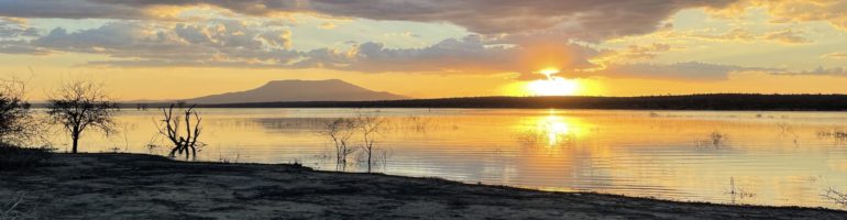
We woke at another stunning Skye parkup featuring this view of Harris and Lewis, which will be our next destination.
It shouldn’t come as much of a surprise that when you build a stone castle on a narrow pinnacle overlooking the sea, it’s a strong defensive position but a weak position for durability, especially in this windy and rainy climate. Have I mentioned the wind lately? So after jockeying for a roadside place to park the bus, we assumed, rightly, that Duntulm Castle would be impossibly perched cliffside high over the sea. It wasn’t a long hike but we couldn’t see much of it until we were on top of it.
The castle was built in the 14th and 15th centuries on a former Pictish stronghold that later saw the feuding of the Macdonalds and Macleods. The Macdonalds claimed the upper hand in the 17th century but by 1732 the fortress was abandoned.
The castle was built mainly for defense but you’ve got to have a few luxuries in life. For instance, how could you not put in a picture window with a view like this?
Turns out on the Isle of Skye first you get the rainbow then you get the wind and rain. We were sopping wet by the time we got back to the van.
It’s a blessing and it’s a curse. It makes life easy while making it worse. It’s this handsome bridge to the Isle of Skye. You don’t need a ferry, you just drive on over. Well, you and just about every other RV owner in the UK. We soon found ourselves nuts to butts in a camper van bouncing along Skye’s potholed roads in a conga line winding our way apparently towards the same destination. It’s the Big Enchilada of Skye, kind of like heading south on I-95 in the US and you start seeing signs for “South of the Border” several hundred miles before the actual venue. If you ever headed South with a child in your car it’s safe to say you’ve been there. As a matter of fact, I remember my parents trying to explain the meaning of the term “tourist trap” to a tearful me as we drove on by.
For the Isle of Skye it’s the Fairy Pools. One wonders where they could possibly put all of these RVs. Well, they put them in a massive rough gravel parking lot terraced into a mountain, directed by every teenager in Skye. There’s no indication where the Pools are but this parking lot represents a serious hike just to get out of it.
We could see a mass of fellow thrill seekers gathering a km up a steep grade and we headed towards them. Stopping for a breather we tried to see the fairy pools but the valley before us was so majestic that we figured it must be somewhere over there.
Didn’t enjoy the down bits of the gravely hike but inevitably we started back up the mountain beside the gorge which apparently contained the Fairy Pools.
With little rain lately neither fairies nor pools were much in evidence.
Some of our party were not amused and stubbornly sat down refusing another step while Yours Truly soldiered on until the last dribble of a stream could be seen.
With thoughts of the long hike back and even longer rutted single lane access road, we turned for home.
Back at the main road most of the RVs turned right toward the main town. We turned left, as we do.
Marce found another cracking parkup which was to become a hallmark of the Isle of Skye.
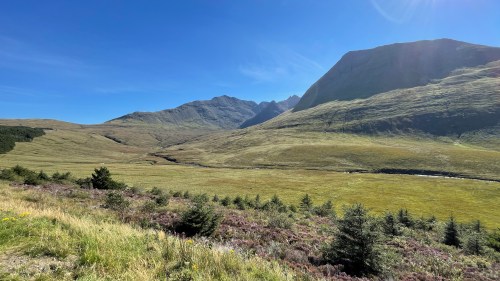
Every mile we drive in Scotland cements its position on my list of Most Beautiful Places. For the better part of ten years we’ve enjoyed picture-postcard tropical views of turquoise waters, brilliant exotic flowers, and the unbroken horizon where the heavens meet the sea.
Now we are far from the equator in a place that rations the sunshine, compresses and mutes the color palette, and teases the horizon behind rolling carpets of heather and gorse. We’ve been lucky enough with the weather to photograph sweeping views under sunshine and blue skies, but even the gloomy days are beautiful, stark and moody. The contrast so well describes Scotland and its people, witty and brilliant but with the dark undercurrent of a violent history.
Still with no plan, and eschewing the tourist stops suggested in the guides to the North Coast 500, we spend our days tooling south more or less toward the Hebrides. I also keep my eye on the weather and my apps hoping for another shot at seeing the northern lights before we get out of range. The weather is the biggest barrier. Even on days when the sky is clear at four o’clock by dark the horizon is obscured by thick clouds.
There’s no shortage of free parkups in Scotland and we’re aware of how special this is. We’ve been warned that England is not so friendly to free camping and that will affect our route and budget when we get there.
We’ve seen a lot of unusual warning signs through the years but this migratory toad crossing is a first for us. I admit I didn’t know they migrate.
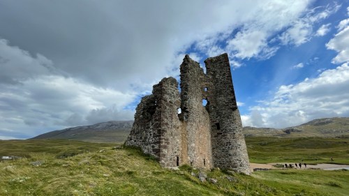
On the road one day I spied a castle ruin off in the distance. Had I been following a map or guide I’d have known it was there but it was a complete surprise to us.
We were well past it before we decided it was worth a stop, and by the time we got turned around, found a safe place to park, then took a wrong path and had to wade across a stream to get to it, we were both a little cranky. But it was a castle, Jack’s favorite thing to explore, and he took off, examining and photographing every detail.
This is Ardvreck Castle, built in the 15th century by the MacLeod clan, then captured by Clan Mackenzie in the 17th century along with the surrounding lands.
The MacKenzies built a more modern manor house across the loch in 1726 but ten years later it was destroyed by fire. You can see the ruin from the castle.
While Jack explored I was distracted by the approaching roar of a half dozen serious touring motorcycles. As the helmets came off I could see these were not young pups, but balding, slightly paunchy, leather-clad old road warriors out for some senior fun.
I asked if they were a club but no, just old friends on a weeklong trip from Ireland. The way they teased and cajoled each other made me smile and they obliged a request for a photo. How lucky they are to have long-time mates to share adventures with.
We continued south through more gorgeous scenery, stopping again to hike up to a waterfall. The waterfall was disappointing but the walk through the forest and the view were worth it.
It’s been a while since we’ve been stopped by large animals on the road. The last time it was elephants in Tanzania.
After a bit of flotzing and faffing we finally decided to forego the challenging mountain pass at Applecross and begin our Hebrides journey. Another couple of sunset parkups brought us to within sight of the bridge to Skye. That’ll be tomorrow.
As always, we arrived at our destination with no plan, no parkup, not even a decision on whether to go East or West off the ferry.
No matter which way we go we’ll be joining the North Coast 500, a scenic loop around the highlands that attracts thousands of tourists every year, many in campers and RVs. We’re not excited about joining a procession of holiday-makers but it’s inevitable that we’ll run into some crowds.
We chose to get the most touristy thing out of the way first and turned East toward John O’Groats, the northernmost point of mainland Scotland. It’s not really — Dunnet Head claims that distinction — and it’s funny that we traveled south to get there, but it’s a significant Point of Interest on the NC 500 map with the usual souvenir and ice cream emporia separating tourists from their money.
Photo op achieved, we turned against the flow and headed westward. I was monitoring a couple of online sources and found NC 500 tourists spend as few as four days to complete the 516 mile loop, with a week or two the average, and clockwise as the preferred direction. We Escapees have of course chosen the opposite direction.
To our surprise and delight we passed very few vehicles those first couple of days. After months in Shetland and Orkney we were used to empty roads but we welcomed the trees and patches of forest.
For some inexplicable reason Google Maps navigated us off the main road and down a steep and narrow lane to the shore of a loch. I could almost be convinced that Google Maps has learned our preference for end-of-the-road destinations because this is not the first time we’ve been guided off a perfectly good route and down a challenging track, often ending in an unexpected and beautiful place.
Luckily the little lane lead us back up to the main road where we took full advantage of every scenic overlook.
A couple of short drive days brought us to this perfect parkup overlooking the beach at Durness. That night it became one of our favorite parkups ever.
A few weeks earlier we’d had a text from a friend asking if we’d seen the northern lights. Apparently there was strong aurora activity on the nights surrounding my birthday in mid-August and the lights were visible all the way south to England. We had no idea the aurora would be visible here, and I kicked myself for not knowing because we were in Orkney at the time, a place with little light pollution and clear horizons.
Since then I downloaded four apps to monitor the skies and set up alerts on my phone. As darkness fell at Durness my phone pinged and I set about searching online for tips on how to photograph the northern lights. While Jack slept I positioned our camera outside the van and attached my phone to the driver’s side window, both set for timelapse according to the online suggestions. It was freezing and I sat inside in my puffy jacket watching the sky. Ping, ping, ping!
And there it was, the Aurora Borealis, a lifelong bucket list item. We were far south, relatively speaking, so the lights only ranged 30-40° above the northern horizon, but the night was clear, there was minimal light pollution and for once Scotland didn’t obscure the sky with clouds.
I woke Jack and he took a quick look, oohed and ahhed for a minute or two then crawled back under the warm duvet. I think his bucket list runs more to the F1 race at Silverstone but I was in heaven.
It took a few tweaks but I got my first Aurora video on the iPhone. I’m hooked!
In three days the ferry will take us back to mainland Scotland and we suspect there are many things Orkney has not yet revealed. We start with the Orkney Museum in Kirkwall. We’ve walked past its beautiful arched doorway dozens of times but bad timing or a busy schedule made us say, ”maybe later.” Today will be later.
The museum tells the story of Orkney from the Neolithic period through the present. We’d already learned much of the history from other museums and visitors centers we toured, so most interesting to us here are the Kirkwall-specific exhibits and Orkney art and craft through the ages.
You’ll have to read about this one here. It’s worth it. I mean it.
This practical chair features a drawer on each side of the base, one side for a bible, the other for whiskey, which I think we can agree is the best way to study religion.
There are plenty of examples of the designs and writings of the Picts and the Vikings.
Marce’s favorite exhibit was learning to spell her name like a Viking might, to which she applied her considerable talents and energy.
There’s one Kirkwall parkup we haven’t tried yet, Scapa Beach, adjacent to a section of the St. Magnus trail. We followed the grassy track up to a sweeping overlook toward the Scapa Distillery. There’s that religion-whiskey intersection again. I think we’re finally starting to understand the essence of Scotland.
We agreed that for our last tango in Orkney we’d return to our favorite parkup behind the golf course along Hoy Sound.
It was a beautiful place to celebrate our 32nd anniversary.
On an evening walk we discovered that the old ruin near our parkup used to be a lifeboat station until they realized they could only launch the rescue boat during high tide. Oops. The station was relocated.
Tomorrow we’ll board the ferry to Scrabster and leave the northern isles of Scotland. It’s been a beautiful journey, enlightening, often surprising, the people warm and welcoming. We always found everything we needed or wanted, from camper supplies to gourmet cheeses. And the scenery never failed to take our breath away.
The next morning we said goodbye to Orkney, and as we rounded the tip of Hoy, we waved a final farewell to the Old Man.
It took a couple of days to recover from the Old Man hike. It wasn’t the distance or the time that did us in, but the long stretch of uneven rocky trail that stressed Jack’s deteriorating knee and my previously broken and frequently sprained ankle. We were glad to get back down without mishap, but we took full advantage of our beautiful parkup to rest before turning Escape Velocity towards the ferry.
We navigated toward Lyrawa Hill, missed the turnoff and had to double back, finally reaching the summit on a potholed track to the most expansive view over Scapa Flow to the Orkney mainland.
As we explored the hilltop we discovered we were back in the part of Hoy that still bears the scars of the infrastructure of war.
Lyrawa Hill was the site of a heavy anti-aircraft battery. There were four guns here of the 120 total installed by 1940 to protect the Royal Fleet anchorage.
When we came to Orkney we had no idea we would see so many remnants of war. The bunkers and batteries are everywhere and a reminder to us Americans, who haven’t fought a war on our own soil in 150 years, of the effort, the cost, the toll in lives and land, of war. Standing on this hill now with only the sea and the wind as soundtrack, I wish all peoples everywhere could know peace.
Much as we’d like to stay on that hill a little longer we have a ferry booked. On our way back down we passed a sheering operation. “Stop!” I yelled, and I jumped out of the van and ran back to the men, who may have been father and son. I asked if they minded if I took some photos.
“Most people don’t ask,” the older man said. “They just shoot and drive away.”
This was just a small number of the sheep getting a summer haircut today, he told me. They had already done dozens more and he pointed to nearby barns and enclosures. I marveled at the speed of the younger man with the clippers.
“He’s very fast,” agreed the older man.
I asked if the wool was processed here on Hoy, but no, they send it to a distributor on the mainland where it’s sold to various processors.
Our last stop in Hoy was the Scapa Flow Museum on the site of the original pump house that supplied fuel to the ships at anchor. The museum just opened in July and kept us occupied for hours. We learned so much about the history of Scapa Flow. We were too occupied with the interpretive galleries to take photos but the episode that most intrigued us was the scuttling of the German fleet at the end of World War I and the subsequent salvage operation. It’s an amazing story; you can read it here.
The pump house has been restored and we had to pull out the cameras for it since we both worked in industrial video and appreciate big machinery and greasy tools.
The museum doesn’t have an interpretive website yet, but you can watch a short video here of how the pump house and collection have been reenvisioned. We thoroughly enjoyed it.
And then it was time to board the ferry and say goodbye to Hoy. We considered staying longer but we only have about six weeks left on our UK visas. It’s time to move on.
We awoke to a quiet but sunny morning. I guess there were no takers on the morning ferry. At least none showed up at the car park. I couldn’t even see any crazies coming from the direction of the ferry after slogging their way through the Glen. They present as tiny dots about halfway up the mountain slowly moving horizontally, right to our left, climbing over stone pasture walls on a slope of 30 degrees or more. Tough going but they join the official trail about half way up the mountain, right before the path kicks up almost vertically. It must be really disappointing. No takers today. What do they know that we do not?
I imagine all you Escapees knew we were going to do it but I wasn’t so sure. I have to confess that any nervousness I may have felt has been replaced with anticipation at what we might discover. This drive to see what I might see has gotten me into trouble more than once but then again I’m still here and willing even if my knee is not.
Hiking poles, boots, tracker, puffy jackets, sandwiches, small amount of water, too heavy for more and we’re off. It’s a bit of a hike just to get to the trailhead.
We immediately start climbing and then the switchbacks begin. We’ve already gained a lot of altitude and the vastness of the Rackwick Valley stretches off into the distance.
This hut is where the Glen trail and the car park trail join forming the steepest section of the trail.
Finally we’ve reached the plateau at the top of the mountain, where it seems like it can’t decide wether it wants to go further up or down so it does a little of both while skirting a dizzying cliff side drop off.
A standing stone and a cairn seem to mark something significant, maybe half way. One of those pebbles is mine.
Soon a glimpse of what I assume is the Old Man, although Marce isn’t so sure.
Turns out it’s a lot further than it looks.
Huge stone blocks form an especially torturous kind of quasi staircase.
Still a way to go and the wind is picking up.
Finally we meet the Old Man of Hoy.
Yes that’s Yours Truly, your intrepid reporter verifying that it’s definitely windy out on the point.
After lunch we noticed the Orkney ferry doing a spot of sightseeing.
After 45 minutes or so of profound appreciation we sadly wished the Old Man well and began the trudge home.
The trail continued to deliver amazing panoramas.
Tail dragging the gravy we clambered back into Escape Velocity after setting an age-adjusted blistering pace. Overall it took just under four hours, and I’d never change a thing. What would it mean if we didn’t even try? You have to try.
We can’t believe the spacious car park at Rackwick allows 7 nights free for campers and caravans, and what’s more, that we never saw more than two others during our time there. There’s also a clean toilet block in an old stone building, not to mention the stunning view. What a perfect campsite!
The car park marks the starting point for the hike to the Old Man of Hoy with nearby Rackwick Beach a destination in itself. It’s a rugged expanse of boulders churned nearly round by the sea and tossed onto a swath of pinkish sand. Mainland Scotland is only about eighteen miles away, but I wouldn’t want to be out there on this choppy sea.
Do I need to mention the wind? We’re still debating whether we’re up to the hike to the Old Man, and this ferocious wind is one of the factors under consideration.
Just above the beach is a traditional bothy offered as free shelter to campers, no reservations required. You can stay inside or pitch a tent in the walled yard. There was no one there the day we visited but during our stay we saw a few cyclists and backpackers take refuge from the weather.
Every day four or five cars arrive at the car park from the morning ferry and we watch the occupants prep for the trek: hiking shoes, rain gear, woolen caps, daypacks, cameras, binoculars, water, trekking poles. We amuse ourselves by guessing the ages of the hikers and make note of the time they return and how knackered they are. On a particularly windy and rainy day a group of four very fit-looking men staggered back and collapsed on the gravel, then fired up a camp stove right in the car park for a warming cuppa. Right then we knew it was prudent to wait for better weather. A wet cliff hike in low visibility isn’t high on my to-do list.
While we monitor the weather we visited the Dwarfie Stane, a Neolithic chambered tomb carved from a massive block of sandstone. It’s thought to be the only one of its kind in Britain, hewn from stone rather than built from stone. The stone is a glacial erratic and measures about 28 feet by 14 feet.
It’s hard to imagine the time and effort required to chisel the entrance and chambers using only other stones.
There’s some 18th and 19th century graffiti. One is an inscription in Persian: “I have sat two nights and so learnt patience.”
Our patience with the weather was rewarded and we picked a good day for the assault on the Old Man. I had to move our ferry reservation back a few days. and when I called the office to change it the clerk assumed we wanted to leave sooner. She sighed and asked, “What time tomorrow do you want to leave?”
“No,” I said. “We want to stay longer.”
“Oh!” she brightened. I guess tourists don’t stay long in a place that has a tough time filling a top ten list of What To Do In Hoy. We love it though, and I think the fact that we’re in our own home wherever we go makes the difference between looking for something to do and just being able to appreciate the beautiful place we’re in.
So, it’s been a while. Kirkwall keeps serving up surprising things to do but inevitably even a tiny palm tree decorated island paradise in the Malacca Strait can get old. There is just no avoiding it. So we are inexorably drawn to it. It’s bigger than us. Passage booked, we are off to Hoy! In addition Marce has found a fabulous free parkup near the jumping off point for the hike to the Old Man. So it’s there if we dare.
We prudently stayed at the Kirkwall town campground to ease camper maintenance, less said the better, and made it to the ferry ahead of schedule.
We’re old hands at ferry protocol but due to the short duration of the trip we just stayed in EV.
Marce planned a few little side adventures on the way to the parkup. First stop was the Longhope Lifeboat Museum featuring the beautifully restored Thomas McCunn in her original rapid-deployment setting. (See link for a short video of the thrilling rapid launch.)
Lifeboats stationed on Hoy respond to vessels in distress in the North Sea and Pentland Firth, some of the most dangerous waters in the world. We were regaled with tales of heroism and tragedy, reminding us of some of the shipwreck memorials we visited in Shetland.
The honored list of lost heros is as impressive as it is sad. When one of the lifeboats doesn’t make it back home, it represents a large percentage of this tiny community’s population including several members of the same family since many fathers and sons serve together.
As sailors we’re grateful for every brave mariner who responds to an SOS. Every time these folks get a call, someone is having the worst day of their lives in some of the worst conditions on earth.
Next up and further down the road was the Hackness Martello Tower, built in 1813 at the height of the Napoleonic Wars. The style of tower derives its name from the original design at Mortella Point in Corsica where in 1794 the French mounted two small cannon on top of a projectile-deflecting round masonry tower some 4 meters thick, which enabled the French to fend off two British warships carrying the combined firepower of 106 guns.
This so impressed the Brits, understanding good value for money, that they built over 100 similar towers in the South East coast of England when Napoleon began gathering his forces to invade Britain. They apparently misremembered the name, and the British towers are called Martello instead of the original Mortella.
So you have a nearly bomb-proof structure housing ammunition, complete gun crew, a cistern for water, and the British innovation of an oval shaped tower, with elevated gun platform for a 24 pounder, replaced fifty years later by a 68 pounder.
Two sister towers protected the massive anchorage at Scapa Flow from 19th century American privateers and through both world wars, never firing a shot in anger.
Finally we drove 45 minutes the entire length of Hoy to Rackwick at the end of the road.
On the other side of the mountains the clouds parted and we descended into the vast beautiful valley under a rare blue sky.
Rackwick is the settlement at the end of the earth and the closest you can get to the Old Man of Hoy by car. A good place to stop.
Back in Kirkwall we made a beeline to the ferry office and booked our passage to Hoy. That settled, we loaded the Kirkwall app and set off to continue the guided walking tour we’d started weeks before but never finished. By this time we’ve seen most of the important sites. The tour ended at the cathedral and as we approached the street was uncharacteristically lined with people, with more coming.
We asked a man with a couple of cameras around his neck what was brewing. “They’re bringing some horses through; I’m not really sure.”
It was obvious by his accent that he wasn’t a local but we staked out a spot on the wall in front of the cathedral fence to wait. We saw the local dignitaries in their finery, and tens of crowd control volunteers positioned along the street. Obviously something important was about to happen.
Soon the Kirkwall City Pipe Band assembled in front of the cathedral and spectators surged up the steps to watch. Jack held our prime spots on the wall while I muscled through the crowd to the band.
When the band finished, the safety volunteers patrolled the wall where we were sitting and instructed us all to go up the steps and behind the fence. We were expecting a parade and wondered why we should move so far away from the action. “You’ll want to be behind the fence,” they urged with a knowing look.
We found a spot behind the fence just in time to hear the mayor (we think) begin a very long welcome address with a bit of history of the pageant we were about to witness. We understood very little of it, of course, but with the help of our spectator neighbors and Professor Google we got the 411.
This is the Riding of the Marches, also called Common Riding. It’s a Scottish tradition dating from the 13th to 15th centuries when there were frequent raids on the towns along the Anglo-Scottish border. To protect the clan from reivers, the local lord appointed a townsperson to ride the borders, or marches.
Nowadays, many towns stage an annual ceremonial Riding of the Marches to celebrate their history. The most well known takes place in Edinburgh, but we could tell Kirkwall loves their tradition too. I think everyone in town came out for the festivities.
At the appointed time the lead riders arrived and lined up facing the dignitaries.
It was soon clear why we needed to move back. Some of the horses took issue with the length of the ceremony and we were glad we weren’t sitting eye to eye with an impatient 500kg beast eager to toss his rider and move on.
After much speechifying and presenting of the flag to the lead rider the procession began.
They would ride to the harbour, then follow a route that will take them along the border of Kirkwall, returning to the center of town in about two hours. We were home by then at one of our favorite waterfront parkups when Jack spied the horses approaching from the direction of the cruise ship dock.
We ran out to catch a few photos but the drizzle and early evening chill sent us right back home again for a quiet night and a warm dinner.