Author Archives: Marce

Dawdling

We have a deadline, and yet we can’t seem to firm up our immediate plans. We drove to Stornaway — a legendary name in sailing circles — for the ferry back to mainland Scotland. Stornaway was a bit of a disappointment, perhaps because we were unsure where to go and what to do.

Still, we did the walkabout and took tourist photos before boarding the ferry to Ullapool.

“No one knows who they were, or what they were doing there.”

Our weather is up and down. Bright sun and blue sky followed by thick cloud cover and heavy rain. Or sometimes light rain. Or high winds. We’ve learned to be prepared for everything and keep an eye in the forecast.

With flights booked and lots to do to before we leave for six months we really should have turned south toward Glasgow to shop and prepare the van for storage. But my Aurora apps were pinging and vibrating with alerts about strong activity at the end of the week. In my latest source of Fear of Missing Out I asked Jack if he would mind driving clear across the country to a place where we might find the perfect conditions for the northern lights — a north-facing horizon, a dark sky with minimal light pollution, and no low clouds. Add that to a new moon and we could hit the aurora jackpot. I found what looked like the perfect place, but it was in the wrong direction and farther than we usually drive, a laughable (by American standards) 120 miles. “Sure,” Jack said, and we even took a longer scenic route at 140 miles.

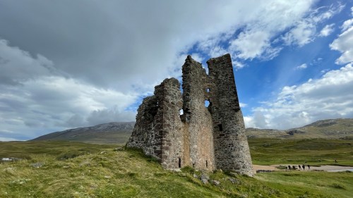
On the way we couldn’t pass up another castle ruin, this one guarded by a large but friendly hairy coo.

Castle Roy is a 12th century fortress that only opened in 2022 after extensive work reinforcing the foundations to make it safe for the public. There’s not much to see, but the setting is lovely and apparently it’s become a popular picnic and wedding spot in the local area.

I find I’m watching the weather forecast almost as much as I did when we were on the boat, and I saw that a front is moving through with high winds predicted. We like to be in a protected spot for that kind of weather, so I found us a quiet parkup along a river popular with flyfishermen. We tucked into a corner beside a graveyard under some tall trees.

The front came through as expected with seriously high winds that made me question the decision to park under the trees. All night we were pelted by leaves and twigs and I worried a larger branch might damage our solar panel.

The rain continued the next day but the fishermen showed up anyway, undaunted, and put in the time whether they caught anything or not.

Finally on the second day the rain stopped enough for me to traipse through the soggy cemetery in search of a Pictish carved stone marked on the ordinance survey map.

After consulting a few websites I finally found the stone embedded in the wall. They say there’s a cross carved into it but the surface is so weathered and eroded you can’t really see it. I couldn’t, anyway.

With the sky clearing by the hour we turned north toward what I hope will be Aurora nirvana.

Leave a Comment

Filed under Uncategorized

Iron and Rock

Archaeologists have identified nineteen megalithic sites in this immediate area and while we haven’t pledged to see them all we do want to visit some of the more important or scenic ones. We’re both fascinated by the urge to erect such monuments, the effort it took, and the locations chosen.

The landscape here, especially under the northern sun, is exhilarating, and at the same time almost soothing. Being able to see long distances, where you can almost perceive the curve of the earth, is always my favorite place to be.

We have a Scottish Islands Passport app that recognizes when we visit a new island. It’s fun to get the ping and a new “stamp,” and for that reason only we drove toward Great Bernera nearby. Little did we know it would involve a sea journey.

“Bridge over the Atlantic” might have been a bit of an exaggeration but it lead to another of the megalithic sites, this one Callanish VIII, which may be our favorite. The view in either direction is breathtaking and the stones themselves are beautiful.

Jack was, as usual, compelled to summit the nearby hill. No matter where we go, no matter how much ibuprofen it takes, he will always get to the top of wherever we are. He’s a High-man.

On the north end of Great Bernera is an Iron Age Village. We assumed this would be a cutesy touristy thingy, but we forgot for a minute that we’re in Scotland and Scots don’t do cutesy. The visit was an enjoyable surprise, and while we only understood about a third of the docent’s strong dialect, she was a knowledgeable and enthusiastic guide. The site, like others in coastal Scotland, was uncovered by a violent storm that eroded the beach in the 1990s. The reconstructed house, dating from the Pictish period sometime after 500AD, is a pretty good depiction of what daily life was like.

Back on mainland Harris we visited more Callanish sites. I could post hundreds of great photos but suffice it to say that being in the place, feeling the wind, gazing at the horizon, and appreciating the beauty of each stone from close up and afar are what make the sites worth visiting. These are special places.

Jack playing the Neolithic Witless Bass. I think he’s out of practice. I heard nothing.

We think this is the tallest individual stone we’ve seen in our travels. I keep touching these things but so far time travel has eluded me.

2 Comments

Filed under Uncategorized

Skye to sea

There’s a funny thing that happens to me when a deadline looms. I panic. I resist. The joy of unstructured wandering vanishes and suddenly I have to schedule, make reservations, backtime. Plan. This is not the way the Escapees live. We are plan averse.

The end of our six month tourist visa is coming up and all kinds of decisions have to be made. Should we leave the UK and continue camping in Europe? If so, how long do we need to stay out of the UK before returning to explore Ireland, England and Wales? What do we need to do to our UK van to make it legal on European roads? And so on.

More important than where to go next is the question of what to do about Jack’s deteriorating knee. He’s hiked heroically all over Scotland but it’s clearly getting more and more painful. We know he needs a total knee replacement but where? And when?

The colder weather tipped the knee decision toward returning to tropical Penang and the same doctor and hospital as knee #1. And to do it now and spend the winter months in a warm place. That’s a win-win. The surgeon assured us he’s still available and gave us advice on lead time and recovery to aid in travel planning.

Once the decision was made to fly to Malaysia we suddenly have a deadline and a long to-do list. And where should we go in our remaining few weeks in Scotland?

We assumed early on we would wander the western islands at the same unstructured make-it-up-as-you-go-along pace we normally employ but now we need to prioritize and squeeze what we can into the time we have left. Skye, while beautiful, has the worst roads we’ve driven so far in the UK, and the weather has become particularly sodden and unpleasant. Even the obligatory hike to the Old Man of Storr got crossed off the list when it looked like the fog was in for a long stay. We just managed to get a quick long shot from the deeply rutted road.

We booked the ferry to Harris and Lewis and called it a day, then found a remote parkup that looked like Aotearoa, the Land of the Long White Cloud, the Māori name for New Zealand. We even had a welcome committee of the ovine ilk.

The weather continued to be wet and gloomy and the crossing was bumpy. Our planned drive around the south end of Harris was nixed because of the driving rain and we found a safe place to park and wait out the weather. It took two days before the rain stopped and we carried on.

1 Comment

Filed under Uncategorized

South

Every mile we drive in Scotland cements its position on my list of Most Beautiful Places. For the better part of ten years we’ve enjoyed picture-postcard tropical views of turquoise waters, brilliant exotic flowers, and the unbroken horizon where the heavens meet the sea.

Now we are far from the equator in a place that rations the sunshine, compresses and mutes the color palette, and teases the horizon behind rolling carpets of heather and gorse. We’ve been lucky enough with the weather to photograph sweeping views under sunshine and blue skies, but even the gloomy days are beautiful, stark and moody. The contrast so well describes Scotland and its people, witty and brilliant but with the dark undercurrent of a violent history.

Still with no plan, and eschewing the tourist stops suggested in the guides to the North Coast 500, we spend our days tooling south more or less toward the Hebrides. I also keep my eye on the weather and my apps hoping for another shot at seeing the northern lights before we get out of range. The weather is the biggest barrier. Even on days when the sky is clear at four o’clock by dark the horizon is obscured by thick clouds.

There’s no shortage of free parkups in Scotland and we’re aware of how special this is. We’ve been warned that England is not so friendly to free camping and that will affect our route and budget when we get there.

We’ve seen a lot of unusual warning signs through the years but this migratory toad crossing is a first for us. I admit I didn’t know they migrate.

On the road one day I spied a castle ruin off in the distance. Had I been following a map or guide I’d have known it was there but it was a complete surprise to us.

We were well past it before we decided it was worth a stop, and by the time we got turned around, found a safe place to park, then took a wrong path and had to wade across a stream to get to it, we were both a little cranky. But it was a castle, Jack’s favorite thing to explore, and he took off, examining and photographing every detail.

This is Ardvreck Castle, built in the 15th century by the MacLeod clan, then captured by Clan Mackenzie in the 17th century along with the surrounding lands.

The MacKenzies built a more modern manor house across the loch in 1726 but ten years later it was destroyed by fire. You can see the ruin from the castle.

While Jack explored I was distracted by the approaching roar of a half dozen serious touring motorcycles. As the helmets came off I could see these were not young pups, but balding, slightly paunchy, leather-clad old road warriors out for some senior fun.

I asked if they were a club but no, just old friends on a weeklong trip from Ireland. The way they teased and cajoled each other made me smile and they obliged a request for a photo. How lucky they are to have long-time mates to share adventures with.

We continued south through more gorgeous scenery, stopping again to hike up to a waterfall. The waterfall was disappointing but the walk through the forest and the view were worth it.

It’s been a while since we’ve been stopped by large animals on the road. The last time it was elephants in Tanzania.

After a bit of flotzing and faffing we finally decided to forego the challenging mountain pass at Applecross and begin our Hebrides journey. Another couple of sunset parkups brought us to within sight of the bridge to Skye. That’ll be tomorrow.

3 Comments

Filed under Uncategorized

To the East, no West

As always, we arrived at our destination with no plan, no parkup, not even a decision on whether to go East or West off the ferry.

No matter which way we go we’ll be joining the North Coast 500, a scenic loop around the highlands that attracts thousands of tourists every year, many in campers and RVs. We’re not excited about joining a procession of holiday-makers but it’s inevitable that we’ll run into some crowds.

We chose to get the most touristy thing out of the way first and turned East toward John O’Groats, the northernmost point of mainland Scotland. It’s not really — Dunnet Head claims that distinction — and it’s funny that we traveled south to get there, but it’s a significant Point of Interest on the NC 500 map with the usual souvenir and ice cream emporia separating tourists from their money.

Photo op achieved, we turned against the flow and headed westward. I was monitoring a couple of online sources and found NC 500 tourists spend as few as four days to complete the 516 mile loop, with a week or two the average, and clockwise as the preferred direction. We Escapees have of course chosen the opposite direction.

To our surprise and delight we passed very few vehicles those first couple of days. After months in Shetland and Orkney we were used to empty roads but we welcomed the trees and patches of forest.

For some inexplicable reason Google Maps navigated us off the main road and down a steep and narrow lane to the shore of a loch. I could almost be convinced that Google Maps has learned our preference for end-of-the-road destinations because this is not the first time we’ve been guided off a perfectly good route and down a challenging track, often ending in an unexpected and beautiful place.

Luckily the little lane lead us back up to the main road where we took full advantage of every scenic overlook.

A couple of short drive days brought us to this perfect parkup overlooking the beach at Durness. That night it became one of our favorite parkups ever.

A few weeks earlier we’d had a text from a friend asking if we’d seen the northern lights. Apparently there was strong aurora activity on the nights surrounding my birthday in mid-August and the lights were visible all the way south to England. We had no idea the aurora would be visible here, and I kicked myself for not knowing because we were in Orkney at the time, a place with little light pollution and clear horizons.

Since then I downloaded four apps to monitor the skies and set up alerts on my phone. As darkness fell at Durness my phone pinged and I set about searching online for tips on how to photograph the northern lights. While Jack slept I positioned our camera outside the van and attached my phone to the driver’s side window, both set for timelapse according to the online suggestions. It was freezing and I sat inside in my puffy jacket watching the sky. Ping, ping, ping!

And there it was, the Aurora Borealis, a lifelong bucket list item. We were far south, relatively speaking, so the lights only ranged 30-40° above the northern horizon, but the night was clear, there was minimal light pollution and for once Scotland didn’t obscure the sky with clouds.

I woke Jack and he took a quick look, oohed and ahhed for a minute or two then crawled back under the warm duvet. I think his bucket list runs more to the F1 race at Silverstone but I was in heaven.

It took a few tweaks but I got my first Aurora video on the iPhone. I’m hooked!

1 Comment

Filed under Uncategorized

Back to earth

It took a couple of days to recover from the Old Man hike. It wasn’t the distance or the time that did us in, but the long stretch of uneven rocky trail that stressed Jack’s deteriorating knee and my previously broken and frequently sprained ankle. We were glad to get back down without mishap, but we took full advantage of our beautiful parkup to rest before turning Escape Velocity towards the ferry.

We navigated toward Lyrawa Hill, missed the turnoff and had to double back, finally reaching the summit on a potholed track to the most expansive view over Scapa Flow to the Orkney mainland.

As we explored the hilltop we discovered we were back in the part of Hoy that still bears the scars of the infrastructure of war.

Lyrawa Hill was the site of a heavy anti-aircraft battery. There were four guns here of the 120 total installed by 1940 to protect the Royal Fleet anchorage.

When we came to Orkney we had no idea we would see so many remnants of war. The bunkers and batteries are everywhere and a reminder to us Americans, who haven’t fought a war on our own soil in 150 years, of the effort, the cost, the toll in lives and land, of war. Standing on this hill now with only the sea and the wind as soundtrack, I wish all peoples everywhere could know peace.

Much as we’d like to stay on that hill a little longer we have a ferry booked. On our way back down we passed a sheering operation. “Stop!” I yelled, and I jumped out of the van and ran back to the men, who may have been father and son. I asked if they minded if I took some photos.

“Most people don’t ask,” the older man said. “They just shoot and drive away.”

This was just a small number of the sheep getting a summer haircut today, he told me. They had already done dozens more and he pointed to nearby barns and enclosures. I marveled at the speed of the younger man with the clippers.

“He’s very fast,” agreed the older man.

I asked if the wool was processed here on Hoy, but no, they send it to a distributor on the mainland where it’s sold to various processors.

Our last stop in Hoy was the Scapa Flow Museum on the site of the original pump house that supplied fuel to the ships at anchor. The museum just opened in July and kept us occupied for hours. We learned so much about the history of Scapa Flow. We were too occupied with the interpretive galleries to take photos but the episode that most intrigued us was the scuttling of the German fleet at the end of World War I and the subsequent salvage operation. It’s an amazing story; you can read it here.

The pump house has been restored and we had to pull out the cameras for it since we both worked in industrial video and appreciate big machinery and greasy tools.

The museum doesn’t have an interpretive website yet, but you can watch a short video here of how the pump house and collection have been reenvisioned. We thoroughly enjoyed it.

And then it was time to board the ferry and say goodbye to Hoy. We considered staying longer but we only have about six weeks left on our UK visas. It’s time to move on.

Leave a Comment

Filed under Uncategorized

The Hoy life

We can’t believe the spacious car park at Rackwick allows 7 nights free for campers and caravans, and what’s more, that we never saw more than two others during our time there. There’s also a clean toilet block in an old stone building, not to mention the stunning view. What a perfect campsite!

The car park marks the starting point for the hike to the Old Man of Hoy with nearby Rackwick Beach a destination in itself. It’s a rugged expanse of boulders churned nearly round by the sea and tossed onto a swath of pinkish sand. Mainland Scotland is only about eighteen miles away, but I wouldn’t want to be out there on this choppy sea.

Do I need to mention the wind? We’re still debating whether we’re up to the hike to the Old Man, and this ferocious wind is one of the factors under consideration.

Just above the beach is a traditional bothy offered as free shelter to campers, no reservations required. You can stay inside or pitch a tent in the walled yard. There was no one there the day we visited but during our stay we saw a few cyclists and backpackers take refuge from the weather.

Every day four or five cars arrive at the car park from the morning ferry and we watch the occupants prep for the trek: hiking shoes, rain gear, woolen caps, daypacks, cameras, binoculars, water, trekking poles. We amuse ourselves by guessing the ages of the hikers and make note of the time they return and how knackered they are. On a particularly windy and rainy day a group of four very fit-looking men staggered back and collapsed on the gravel, then fired up a camp stove right in the car park for a warming cuppa. Right then we knew it was prudent to wait for better weather. A wet cliff hike in low visibility isn’t high on my to-do list.

While we monitor the weather we visited the Dwarfie Stane, a Neolithic chambered tomb carved from a massive block of sandstone. It’s thought to be the only one of its kind in Britain, hewn from stone rather than built from stone. The stone is a glacial erratic and measures about 28 feet by 14 feet.

It’s hard to imagine the time and effort required to chisel the entrance and chambers using only other stones.

There’s some 18th and 19th century graffiti. One is an inscription in Persian: “I have sat two nights and so learnt patience.”

Our patience with the weather was rewarded and we picked a good day for the assault on the Old Man. I had to move our ferry reservation back a few days. and when I called the office to change it the clerk assumed we wanted to leave sooner. She sighed and asked, “What time tomorrow do you want to leave?”

“No,” I said. “We want to stay longer.”

“Oh!” she brightened. I guess tourists don’t stay long in a place that has a tough time filling a top ten list of What To Do In Hoy. We love it though, and I think the fact that we’re in our own home wherever we go makes the difference between looking for something to do and just being able to appreciate the beautiful place we’re in.

Leave a Comment

Filed under Uncategorized

An unexpected parade

Back in Kirkwall we made a beeline to the ferry office and booked our passage to Hoy. That settled, we loaded the Kirkwall app and set off to continue the guided walking tour we’d started weeks before but never finished. By this time we’ve seen most of the important sites. The tour ended at the cathedral and as we approached the street was uncharacteristically lined with people, with more coming.

We asked a man with a couple of cameras around his neck what was brewing. “They’re bringing some horses through; I’m not really sure.”

It was obvious by his accent that he wasn’t a local but we staked out a spot on the wall in front of the cathedral fence to wait. We saw the local dignitaries in their finery, and tens of crowd control volunteers positioned along the street. Obviously something important was about to happen.

Soon the Kirkwall City Pipe Band assembled in front of the cathedral and spectators surged up the steps to watch. Jack held our prime spots on the wall while I muscled through the crowd to the band.

When the band finished, the safety volunteers patrolled the wall where we were sitting and instructed us all to go up the steps and behind the fence. We were expecting a parade and wondered why we should move so far away from the action. “You’ll want to be behind the fence,” they urged with a knowing look.

We found a spot behind the fence just in time to hear the mayor (we think) begin a very long welcome address with a bit of history of the pageant we were about to witness. We understood very little of it, of course, but with the help of our spectator neighbors and Professor Google we got the 411.

This is the Riding of the Marches, also called Common Riding. It’s a Scottish tradition dating from the 13th to 15th centuries when there were frequent raids on the towns along the Anglo-Scottish border. To protect the clan from reivers, the local lord appointed a townsperson to ride the borders, or marches.

Nowadays, many towns stage an annual ceremonial Riding of the Marches to celebrate their history. The most well known takes place in Edinburgh, but we could tell Kirkwall loves their tradition too. I think everyone in town came out for the festivities.

At the appointed time the lead riders arrived and lined up facing the dignitaries.

It was soon clear why we needed to move back. Some of the horses took issue with the length of the ceremony and we were glad we weren’t sitting eye to eye with an impatient 500kg beast eager to toss his rider and move on.

After much speechifying and presenting of the flag to the lead rider the procession began.

They would ride to the harbour, then follow a route that will take them along the border of Kirkwall, returning to the center of town in about two hours. We were home by then at one of our favorite waterfront parkups when Jack spied the horses approaching from the direction of the cruise ship dock.

We ran out to catch a few photos but the drizzle and early evening chill sent us right back home again for a quiet night and a warm dinner.

2 Comments

Filed under Uncategorized

Should I stay or should I go?

We keep reading reviews on various travel and hiking sites of the trek to the Old Man of Hoy. This is how indecisive we are. But when half of the reviews swear it’s a 30-minute heavy-breathing uphill followed by an easy overland romp, and the equally adamant other half report a challenging slog over rough terrain all the way, you can understand our reluctance to commit. And as far as we know, the Old Man is pretty much the only reason to make the journey to Hoy. In fact, we read there are people — and we question their sanity — who take the morning ferry, hike from the dock to the start of the trail, hike up the trail to the Old Man, then hoof it all the way back in time for the mid-afternoon ferry, a distance of about 14 miles and 2500 feet of elevation gain. AllTrails calls this “moderately challenging” and warns to stay well back from the cliff edges and not to attempt in wet weather, high winds, or low visibility. It’s Scotland. Rain, wind and fog are a given. But Jack’s remaining OEM knee is starting to complain about too much hiking, and I’m always mindful of what a misstep on a rocky path could do to my trick ankle. Old people problems, I know.

On the other hand, we’re so close and it calls to us. We know we’ll kick ourselves later if we don’t do it. We still regret not crossing the scary swing bridge to climb the wonky ladder and sit in a 600-year old kauri tree in New Zealand back in 2016. We both chickened out and we feel bad about it to this day.

While we play “will we or won’t we?” with the Hoy question we continue our drive around the East Mainland. There’s less focus on the Neolithic here and more on WWII. It’s also less populated, less developed, and certainly less touristed. We have the place largely to ourselves. Even the honesty boxes are mostly empty of homebakes and just stocked with convenience store snacks.

We had high hopes for the pretty village of St. Margaret’s Hope, but it didn’t satisfy our café craving.

After a couple of quiet nights in peaceful parkups we ran out of ideas for this side of Orkney and turned back to Kirkwall to see if we can book a ferry to Hoy. Yes! We’ve decided to go!

Leave a Comment

Filed under Uncategorized

And now for something completely different

Hundreds of years after the architectural contributions of the brutal Black Earl et al, another team of forced laborers created a triumph of wartime shortages and homesickness on the tiny island of Lamb Holm on the eastern shore of Scapa Flow.

Scapa Flow is a wide body of water bordered by the Orkney mainland, Hoy, and the isles to the south and with a shallow sandy bottom. It’s one of the best natural harbors in the world, used at least as long ago as the Vikings as a safe and sheltered anchorage in the North Sea.

Map By Siałababamak – Own work, CC BY-SA 3.0, https://commons.wikimedia.org/w/index.php?curid=6207501

There’s some history to catch up with, so bear with me. At the beginning of the 20th century, Britain thought they might want to relocate some of their naval fleet to better defend against the buildup of the German navy on the North Sea. After a few false starts at other locations, Scapa Flow became the main base of the British Grand Fleet. To protect against attacks by German U-boats, the channels between the small islands to the south were fortified with mines and blocked with sub nets, booms and eventually block ships.

These efforts were largely successful with only a few failures but by the beginning of World War II the block ships had collapsed and the previous defenses proved inadequate. In October 1939 a German U-boat breached the perimeter and sunk the battleship HMS Royal Oak causing the loss of over half the 1400-man crew. Three days later Scapa Flow came under attack by Luftwaffe bombers.

In response, more blockships were sunk, more booms and mines were deployed, and anti-aircraft batteries were installed to defend the fleet. Winston Churchill ordered the construction of causeways linking the small islands to the southeast, essentially blocking the entrance to Scapa Flow from that direction. The causeways are now called the Churchill Barriers.

By that time there were hundreds of Italian prisoners of war encamped in Orkney and they were set to work constructing the barriers. At first the prisoners went on strike, claiming the Geneva Conventions prohibited prisoners of war from being forced to support the war effort. In response, the Brits claimed the barriers were only meant to improve communication between the small southern islands and mainland Orkney. You be the judge. In any case, the Italians ended up working on the barrier project.

Far from home and missing their culture, a small group of Italian POWs petitioned their captors for permission to build a chapel. They were given two Nissen huts which they connected end to end, then lined the inside with plasterboard, scrounged for scrap materials, bartered for paint, and set to work.

The result is a masterpiece of ingenuity, talent, faith and dedication, and the best example of trompe l’œil either Jack or I have ever seen.

A sign at the entrance asks visitors to refrain from touching the walls, but of course the first thing Jack did was reach out to feel the smooth surface of the plasterboard, that’s how good the illusion of 3D is.

The base of the holy water stoup is a giant spring covered in concrete. Visitors are advised not to lean on it.

There’s so much to know about every detail of this beautiful little chapel and the men who created it. You can read more here.

And feel free to go down the rabbit hole about Scapa Flow on your own time. Here’s a good place to start. We came to Orkney for the Neolithic sites but ended up fascinated by the dramatic history of Scapa Flow. I’ve only touched on a few high points.

Leave a Comment

Filed under Uncategorized