Author Archives: Jack

That’s our story and we’re sticking to it

To be honest, after the Achill Island debacle I’m a little surprised to be sitting here in Escape Velocity waiting, on a blustery day, for a ferry to another Irish island. The plan is to hire bicycles to explore the small island. We can feel the motion of the ferry change, rising to the ocean swell as we leave the protected bay, or lough, as the Irish seem to call anything with water in it. It’s so familiar, like coming home for this old sailor.

I’ve never felt so popular walking down the long pier toward Inishmore Island.

It seemed that the whole island turned out to welcome and pitch their wares to their new best friends, like a pop-up carnival of balloons, bus tours, cotton candy, horse drawn buggy tours, hotdogs, and guided bike tours with every permutation imaginable.

By the time we reached land our sales resistance was at a dangerously low ebb and a bemused but whimsical older gent smiled and said, “Would you like to sit down in my shiny new Mercedes minibus?” Why yes, we would. It was far too windy for bike riding. That’s our story and we’re sticking to it.

Soon we were on our way, just one happy minibus load of adventurous funseekers. It didn’t take long before it became obvious that the impossibly narrow roads were choked with tourists, backpackers, and optimistic bike riders, pushing their bikes in the fresh breeze. If there weren’t any serious injuries that day I would call it an act of divine serendipity. I confess that our whimsical driver seemed to take all this madness in stride. I was impressed with his wheel prowess. Turns out we were slowly weaving our way between the high tight stone walls, pinching in on both sides of the road, toward Fort Dun Alonghasa, built in the 1,100s BC on top of a high promontory sea cliff.

Like all high value venues the path starts out easy enough but as soon as you’re not paying attention bam, you’re crawling up over rocks at a ridiculous angle.

I’m sure that 3,500 years ago the road up to the fort made sense but let’s just agree that in the last 3,500 years some deterioration may have occurred.

Marce found a fast track around the worst

The queue, laboring slowly up the long hill began to take on the feel of a deep breathing religious procession or pilgrimage of penance.

It’s funny but I never had that thrilling feeling of standing where ancient man has stood. I don’t know, it might just be oxygen deprivation.

The original dry stone defensive ring is D-shaped and contains quite a large area.

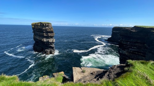
Spectacular views from the fort.

Well we don’t want to turn Mr. Whimsy’s smile into a frown now do we? We have very little time for lunch so it’s time for our descent.

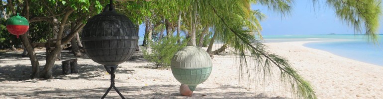
Don’t know how I missed this explosive cairn creation on the way to the fort.

This tin whistle busker was good enough that for a moment I could forget about my sore feet

You know how there’s aways someone on a tour bus that can’t seem to get back to the bus on time? Well this time it was Yours Truly but I have to admit the shepherd’s pie I had for lunch was well worth the dirty looks our fellow happy passengers gave us as we clambered aboard a few minutes tardy.

Soon we found ourselves again squeezing between the impossibly tight stone walls in search of a venue called “The Abbey.” This is Ireland, there’s always an abbey. Driving around the island it’s easy to imagine a tough rocky life.

There were small plots of land, mostly rocks and the odd patch of grass, delineated by dry stone walls with random gaps to, they claim, bleed off wind pressure.

It’s a popular stop and Mr. Whimsy had a spot of bother weaseling the big van into what passes as a proper parking spot here on Inishmore Island. Down below us was, more or less, a beautiful 15th century abbey.

By this point our driver’s wry smile was missing and all we got was “Gotta go, let’s get in the van.”

We passed a supposedly typical Inishmore homestead built for “Man of Aran,” a 1934 film by Robert Flaherty about pre-modern life on the island. It was a landmark (and somewhat controversial) film, and if you’ve got the time it’s well worth watching here.

Back in town we joined the throngs admiring the classic fisherman’s sweaters and resisted the temptation to buy. Where in a campervan would we fit one, let alone two?

We spent our last moments on Inishmore with coffee and cake and wondered about the changes a place as beautiful and as tough as this island would make in your life.

On the way back to the ferry the harbor was at low tide and that changes everything.

Leave a Comment

Filed under Uncategorized

World turned upside down

We landed quayside in lonesome Blacksod Bay.

It turns out we’re within spitting distance of a small but charming lighthouse and the world famous Old Smokehouse.

About 80 years ago Ted Sweeney was the lighthouse keeper and also the town’s weatherman. After analyzing the weather data one day in June with the help of two female clerks, he felt there would be a small weather window between two building North Atlantic storms coming their way.

In the meantime, at the Old Smokehouse, it just might have been the best hot smoked salmon I ever ate, but that didn’t turn anything upside down. What did became apparent when we met a fellow traveler in a little camper who motioned toward the lighthouse and told us his grandmother worked at the town’s only post office and wireless station, and he’d always wanted to visit where she’d worked. The post office was housed in this very lighthouse.

The weatherman and postal clerks didn’t know it then but their forecast put the D-Day invasion in motion when their message was sent from Blacksod Bay the 4th of June, 1944.

Our camper neighbor was proud of his grandmother and he’d come a long way to see the lighthouse and celebrate her role in D-Day.

Eighty years earlier, famine and poverty dogged Blacksod Bay and West Ireland in general. James Hack Tuke, a Quaker, saw that the land could no longer support the population and he organized and paid for a boat lift in 1883-1884 for some 3,300 Irish families.

They sailed to Boston and Quebec but the last place they saw in Ireland was Blacksod Bay.

A memorial commemorates those families and the ships they sailed away in. Each plaque shows the ship, the destination, and all the names of the crew and passengers.

Marce says this a gift to any family historian descended from one of these families.

The mass emigration in the 1890s probably explains how empty the place still feels to this day.

Heading up into the hills out of Blacksod Bay we found another major blow hole and one of 90 some promontory ring or cattle forts in County Mayo.

Dún na mBó, like most of these forts, is protected on three sides by sea cliffs. Stone walls were only constructed across the land at the narrowest part of the headland.

I’m sure they were exhausted constructing all these bloody walls all over creation.

Not much of the stonework exists but that blowhole sure has survived.

Next we crossed the bridge to Achill Island which, in reasonable weather, is one of the top destinations in County Mayo.

There is nothing reasonable about this weather but adhering to the EV paradigm we POR’ed, which sometimes works.

We passed through areas we assumed were picturesque and charming but for the fog and rain.

We reached the famous beach at the end of the island and parked to wait for Achill’s clouds to part.

We gave it an hour.

Sometimes the magic works, sometimes it doesn’t.

We cranked up EV and climbed back up the steep winding road over the mountain. The weather, if anything, was worse.

We were determined to rid ourselves of this sopping funk. We set our sights on another beach area called Silver Strand. With the rain hot on our heels, we wound our way down through the adventurous narrow serpentine access road where it was not yet raining, just threatening.

In the morning the water, spread thinly over the shallow sandy bay, had disappeared far out into the Atlantic.

There were warnings and life preservers laughingly distributed far inland around the edge of the huge sandy beach but then I realized given the wrong set of circumstances, like wind and storm surge, this whole bay could suddenly flood and trap people in rip tides. The life saving equipment started to make sense.

The hike across the soft sandy bay had to have been at least a kilometer and the footing was quite difficult.

Somehow we found people swimming further out in the freezing incoming waves. This I do not understand but they seem to be enjoying themselves.

The hike back was just as tough in the soft sand but Silver Strand, surrounded by mountains, still held surprises for us.

1 Comment

Filed under Uncategorized

The story of the broken fort

Today’s parkup features a gorgeous seaside cliff view with a long, gentle grassy slope up towards tomorrows adventure. The day dawned unusually sunny but with the usual stiff breeze. Along the cliff we found a blowhole covered with a much appreciated huge steel grate to keep us funseekers from falling a hundred or so feet down into the ocean.

The ocean views only improved as we climbed the hill along this craggy coast.

Reaching a plateau, we came upon an otherworldly area that had what can only be described as strange puffy pockets of grassy turf.

So springy, it was as though they were filled with foam rubber or air pockets, making it extremely difficult to walk on.

Hilking through this area one feels like a drunken sailor or as if walking through the funhouse at an amusement park. Turns out the pockets are filled with spongy sphagnum moss which absorbs quite a bit of water, and is not the most secure feeling when walking on the edge of a cliff in gusty wind but a thrillseeker’s got to do what a thrillseeker’s got to do.

We’ve seen “Eire 80” spelled out in huge letters and numbers, laid out on Malin Head, also a conspicuous headland, and we’re told they’re to inform airplanes that Ireland is neutral, they are about to enter Irish airspace and — I’m going to make a leap here — it also means YOU ARE HERE at “Eire 64.” We have no drone. Use your imagination.

What differentiates this sea stack from others we’ve seen is that the ruins of an ancient residence still exists on the surface of the sea pillar.

As part of its fortifications, a natural land bridge once spanned the 80 meters to mainland Downpatrick Head. In 1393 a hurricane washed the land bridge away falling the 50 meters down into the North Atlantic leaving families stranded on the new sea pillar island. Eventually they had to be evacuated, rescued using ship’s ropes. Of course the Irish being Irish there are always going to be more than a few myths or folk tales about how the land bridge fell: mythical ogres and such. Even St. Patrick, livid that he couldn’t convert Chief Crom Dubh to Christianity, clove the land bridge with his shepherd’s crook and left him to starve to death on the newly created “island.” A believe-or-die kind of proposition.

No, I agree he doesn’t look that fierce, really almost meek, but I suppose we all have a dark side.

Continuing to the end of Downpatrick Head we find more religious zeal in the form of a sport I call high altitude fishing while clinging to cliffs in a stiff breeze, at a vertigo-inducing height.

Retracing our path back down the hill we found another major blowhole fed with a 400 foot tunnel from the ocean.

It seems that during the 1798 rebellion 25 rebels hid in this tunnel while the British scoured the area. Unfortunately the rebels were trapped and drowned at high tide.

With that grizzly scene replaying through my mind we reached Escape Velocity and I noticed a brilliant flash of light at the top of the mountain across the bay, the same mountain we will cross tomorrow. I’d seen it before. It reminded me of the bright reflection of sunlight that sometimes you see off a car mirror or the glint off an airplane window, but this was randomly flashing brilliantly from the same spot. I focused the binoculars on the source and, if I didn’t know any better, I’d guess that sticking up over the top of the mountain was a pyramid! Turns out it is. We had blunderstumbled onto the welcome center for the world famous (but previously unknown to us) Ceide Fields complex.

At 5,500 years old, Ceide Fields is oldest known field system in the world. The site is queued up for admission to UNESCO World Heritage status.

Stone walls delineated every field for miles around the mountainside indicating a complex farming community. Bog began to encroach on the fields and eventually covered most of it. In these local conditions the bog, usually very slow growing, covered the site at the rate of about a meter per thousand years. Eventually the site was abandoned and forgotten until a farmer in the 1930’s discovered a buried stone wall while cutting turf.

Once again no one knows why or exactly when the fields were abandoned but the only way to find the stone walls now is by probing the turf with a long metal rod until they hit the top of a wall. In this way scientists are mapping the fields without disturbing the landscape.

Two rare insectivorous plants grow here.
That’s Downpatrick Head in the distance.

Get a deeper dive into Ceide Fields here.

Sweet dreams from Downpatrick Head

Leave a Comment

Filed under Uncategorized

Extravagance

Tonight’s parkup features beautiful Lough Glencar, which pales before the magnificent green Truskmore mountains that surround us. Unfortunately the parking lot is nearly as slanted as the mountains. Note to self, buy better ramps.

We’ve scheduled a full slate for today so do endeavor to keep up.

We’d noticed a cute cafe just across the road and in the morning found it, wait for it…closed for breakfast. On the way we noticed a sign that pointed toward a waterfall. I like a good waterfall but opportunity waits for no one so breakfast will have to.

We’re heading for a real crowd pleaser this morning called the Great Horseshoe loop. If getting there is just half the fun I’m not sure I can take much more.

The scale of this bowl shaped valley is impossible to wrap your head around. It’s so magnificent that sound hasn’t a chance to disturb the tranquility of the place. It just dissipates like vapor on a hot day.

And what is the deal with this large mysterious house out in the middle of all this magnificent loneliness?

And why are 30 or so souls (discreetly not shown) gathered around a guy who looks like he is going over a clipboard with statistics and a drawing of property borders? Is this building ripe for developers? Or have I just read this wrong?

Regardless, we pressed on with the Great Horseshoe Loop but soon found we were off the map and lost again.

Google and the gods of GPS found us and we laid a course for what is billed as a megalithic cemetery in Carrowmore. Access to the site, or should I say sites, is through the gift shop and a small visitor center which repeated the mantra: no one knows who they were or what they were doing there. Yes, no one knows who did this or how they did this, or why they did this but it might have been, in this case, just fancy head stones.

I guess these people had little else beside land because by today’s standards, where everyone is jammed in on top of one another, this huge plot of ground contained just 30 odd generous sites. It was a hike just to get to the first small numbered site.

By the time we reached the Big Kahuna in the large stone ring on top of the hill, we were already considering how far away the parking lot is.

Looks like a pet rock cemetery in here.

Marce found a nice little parkup in Knocknarea up on Strand Hill. Early reports boast of a fine coffee/hot chocolate vendor on site. However it was not made clear to Yours Truly that a well known mountain hike up to another massive stone cairn, the largest in Europe, might be in the offing. Before I could protest I found myself wobbling up a 5,000 year old, ankle-breaking stone path, having lost with my lame arguments about how it looks like it might rain, and isn’t it kind of late Hon, don’t you think? Never lead with a question!

You have no idea where the climb will end and it’s so steep that occasionally rudimentary rough steps are cut into the mountain or rocks are placed as steps. I will say that as we slowly make altitude the view improves with every step. It’s just that there are so many steps, and so very steep.

We begin to take short rests just bending over where we stand, and even the occasional bench shows up.

This climb is a tough one.

Finally we begin to see the very tip of the rocky top of what is known as the 5,000 year old Maeve’s Cairn.

It’s a very large round pile of rocks, approximately 15m tall and 55m in diameter. It’s a lot of rocks.

A possible rule #3 violation: no long hikes without a worthwhile payoff.

By this point just walking around it was exhausting but we could see several paths leading off in every direction with plaques that state how far and what kind of monument one might find at the end of that path. Color my mood just too tired to care.

And then the heavens opened up and proved me right, but wet.

Heading down in the rain proved to be a slippery proposition.

All those slick rocks and wet grass became treacherous, but with gravity assist we made it down. Secure in the knowledge that we’d earned a bit of a rest, the heavens really opened up in earnest. It’s probably just as well that I had no Johnnie Walker with which to celebrate. We’re not going anywhere tonight.

1 Comment

Filed under Uncategorized

Always a flight risk

Yes, we’ve been lolly-gagging in this general area of Ireland for what seems like ages. After complaining that we really hadn’t heard much in the way of local music, an old sailing friend swore that a July 12th demonstration, or march as they refer to it, was not to be missed, and to just think of it as a fun show. As it happens, there’s one scheduled not too far away in Ballinamallard. We can wait around for that.

Still, there’s always something to see in Ireland and, as anyone can see, our track at https://share.garmin.com/escapevelocity can only be described as drunken wanderings. Always a flight risk, apparently we Escapees really need goals and strict adult supervision. Nevertheless I thought I might have a word with you about what we’ve been up to while waiting for the parade in Ballinamallard, while still trying not to wander too far away.

We’d been waiting for the police to find the missing person who disappeared at Slieve League so the mountain would reopen and we could visit the cliffs, but it was more than a week before they found a body and declared it a homicide and by that time we had moved on.

After a brief stop to exchange an empty LPG tank with UK fittings for a rather pricy full tank we soldiered on and, while it wasn’t raining, we thought we’d get reacquainted with the megalithic world at Drumskinney Stone Circle.

The sheer number of stone circles, cairns, and alignments spread over these many acres begs the question, “Who did this, why did they do this, and what does all this mean?” It’s awfully quiet on the answer side of things.

With the resumption of the classic on again, off again light Irish rain, we took to Escape Velocity to enjoy a circuitous forest drive up to a stunning parkup high above Lough Swilly on the Urris Hills.

The following morning dawned sunny and still, only disturbed by 50 or so Audi enthusiasts, determined to shoehorn their cars into our small car park on top of the mountain. We went for a hike.

I’ve noticed aggressive speed bumps bolted all over many car parks in Ireland and I’m beginning to understand why. About the time we got back from our hike the Audis took turns leaving with a burn-out and a horn toot, just as mysteriously as they came. Nobody knows who they were or what they were doing there.

We decided on a change in altitude and Marce found a charming riverside parkup on Lower Lough Erne with a small dock, toilets, and — be still my heart — showers, with enough sunshine to get these photos.

Later those beautiful clouds you see contained plenty of rain and hail which chased us off our folding chairs on the dock, and had us sprinting for EV. Apparently our sailing weather prediction skills have atrophied.

We decided to keep things at or near sea level while working our way towards Ballinamallard. Not content with just a beautiful parkup with a river view, Marce found a place that included an unsolved mystery. I was concerned with the narrow access road that wound its way through dense trees and scrub along the shoreline.

Really it was little more than a path. Sure enough, at the end we found a tiny car park with one of the few trash receptacles in all of Ireland, filled to overflowing with beer cans. Not a good sign.

Taking a walk we noticed a small old rough concrete pier with a municipal looking number on a post right in front of it.

Turns out there are several dozen of the narrow 20 foot long piers with a small T at the end of each, equally spaced and numbered, all along the waterfront.

No one knows who they were, why they did this, or what it all means.

If it’s true that every rain drop that falls on you is a teardrop you’ll never have shed, we should be in good nick this morning for our drive to Ballinamallard.

We have to navigate all the way through town to get to our reasonably priced mid town parkup for the weekend. We found ourselves immediately diverted upon entering town but somehow stumbled back onto the road toward the parkup. No harm no foul, but I’ve never seen such a large empty and barren gravel lot that was supposed to be the rendezvous fall-in central party area for all the bands.

Told to park anywhere, I chose a spot near the front gate but when I realized they were setting up an outdoor beer bar and we’d be directly between the port-a-loo and the beer, we moved to the back of the empty lot. We weren’t born yesterday.

1 Comment

Filed under Uncategorized

Poised for Greatness

As we serpentined our way through Donegal suddenly there was trouble. Barriers blocked our way with the only explanation a small sign that read “traffic diverted.” Google said we were poised for greatness with just a few circuitous blocks to go before we reached the bottom of town where we expected to find a longish strip of a parkup on the River Eske . Just our luck and now this, but we persevered and stumbled back onto the intersection just as it joined the parkup entrance. The next problem was that the parkup was apparently all parked up, looking more like a used RV dealership than a public parking lot.

We slowly trundled through the blinding white sea of aluminum motor homes when just as I was searching for a plan B, I saw it. A small camper van had just vacated a last chance parking space, probably tired of walking so far into town. I admit that I had to jog Escape Velocity back and forth, sometimes making scant progress, sometimes not at all. It was incredibly tight in this lot filled with oversized vehicles, most of which were proud of their designated parking space.

I thought I’d take an orientation walk around the lot, eventually running into an explanation for the crowds and traffic. Welcome to the Donegal Summer FunFest, read a large poster at the entrance to the car park. Live music, vender carts, Celtic classic car meet, special savings at the pubs, even, my personal favorite, face painting were some of the fun filled activities listed, while this vaguely Nordic looking dude points menacingly at Main Street Donegal.

We took his suggestion and headed up towards this charming hamlet.

Dodging the obligatory Irish rain shower or two, we located the stage in the center of town where a fun band called The Tumbling Paddies were knocking out what we’ve found to be a strange worldwide phenomenon, John Denver’s “Country Roads.” Seriously, we’ve heard energetic renditions of this sing-along ditty from Zanzibar to Kathmandu, Thailand to Tasmania and beyond. We’re no longer surprised, we just wait for it.

Back at Escape Velocity we found her inadvertently taking part in a Morgan auto show.

We couldn’t leave Donegal without a tour through the ruins of Donegal Abby which is conveniently located at the end of our parkup.

Turns out the parkup at the end of Donegal was actually centrally located.

Leave a Comment

Filed under Uncategorized

Look but don’t touch

I’ve often felt that the Irish road system was like a hierarchical circulatory system without any evidence of an aorta, a bare minimum of arteries, a fair number of veins, and RV drivers have to fend for themselves on the capillaries. Today we capillaried our way to the Malin Beg headlands, Ireland’s most northernly point, where we were assured to expect a semi level parkup with stunning views, sunny beaches, pleasant hikes, and as a bonus, a Napoleonic era signal tower.

In the US there’s almost always a town in every state that bills itself as “Upside down world” where up feels like down or a ball rolls uphill and everything is magnetic. This parkup was so tilted — or maybe it was the lay of the land surrounding it — that was so discombobulated that it was quite disorienting and every time one of us spotted what looked like a level looking space we’d drive over, park only to find it 4 or 5 degrees off level.

We have an iPhone with an app that gives what we’d thought was an accurate digital readout when left on the floor of the van. I’m beginning to wonder if it works at all. As I’ve said before, we’ve become quite adroit at spotting the most level space in a given lot, but this place has us considering agonizing reappraisals of our skill level. Honestly, we tried them all and even with the help of ramps we were living at a 2.5° deficit. At a 2° tilt things like refrigeration doesn’t seem to work as well in Escape Velocity.

Regardless we’re here for the night but first a hike to the old signal tower was in the offing so it was boots, poles, and due to the wind speed, caps.

There was nothing posted that would help guide us to a trail to the tower. Truth be told we never made it out to the headlands either.

We passed by an awesome flight of stairs that led hundreds of feet down to the beautiful beach below but with respect to rule #3 we are not going to swim in ice cold water, especially in this wind, we can see it very well from up here, thank you, and that’s a lot of steps.

We followed fences through a grassy sheep poop infused path till we came upon this sign .

Now we know that 90 something percent of the time this is not connected to anything electrical but, just the same… Still, this is a beautiful place even though it seems you can’t get out to the headlands. You can still photograph it, you just can’t touch it

Tomorrow we have a serious mountain pass to cross and a waterfall to check out on our way to Donegal. By the way, for you mystery buffs, Slieve League is still closed. No body found yet.

We’ve an old Irish city to navigate to find a parkup. It’s sometimes chock-a-block with campers. Wish us luck.

1 Comment

Filed under Uncategorized

Now for something completely different

We knew that finding a place to park at the touristy Narin beach might be chancy but sometimes you just have to try. When I spotted a car leaving the next to last spot in a long row of parked cars I went for it, somehow squeezing Escape Velocity straight in. What would it be if you didn’t even try? You can’t plan for luck like that, you just stick out your racket and something good might happen. It was far from level and extricating EV out of here will not be fun but I decided to worry about that later. In the meantime the broad expanse of beach in front of us was truly beautiful.

It’s on a scale of beaches in Australia except this strand is filled with shivering Irish families covered up under their expensive Dry Robes, instead of lobster-red nearly naked Aussies baking in the sun. Suffice it to say it’s on the blustery, nippy side here in the Emerald Isle but they’re determined to have fun amidst the general beach brouhaha, and they really do.

The racket coming from the little cafe, across the narrow lane right behind us was shouting “party” but on further inspection was quietly found to have linen tablecloth prices, a strange juxtaposition for a beach vendor. You can drop a lot of coin for a burger and chips here at Narin beach.

It turns out we are going to have to wait until 3:30pm for low tide. What happens at low tide you ask? That’s when the water recedes down to the level where you can wade across Greebarra Bay to Inishkeel Island which features ancient monastery ruins, giving you something to wade to, so to speak.

Most conversation that day went something like, “Is it low enough?” “Not yet, Marce.” I’d seen a couple of people get bowled over in the swirling frigid current so I saw no reason to push it. The water level seemed to drop at a glacial pace all day until suddenly it looked like the beginning of the wading window was at hand. The receding tide exposed so much more sandy beach that now it was quite a hike just to get to the water.

As we entered the bay, we could immediately feel the cold current tugging at our legs.

Small waves that wrap around Inishkeel Island from the left and the right meet in the middle of the sandy bar creating a standing wave.

Gaining ground we negotiated some rocks hidden by seaweed and pressed on to a sandy cove where a handsome sloop was anchored.

At the end of the beach, high on a bluff overlooking the cove, we could see the ancient ruins of St. Connell church and St. Mary’s church, built in the 13th century.

There really wasn’t a path so you just have to force your way up through the overgrown weeds.

For a change we knew who they were and what they were doing there.

It certainly is picturesque.

The breeze is really freshening and the tide is swiftly swirling in, so we have a change of plans and quickly make our way down to the crossing bar.

Tide’s rising

We may have left it a little too long because the current is stronger and up to our knees this time.

The tide may be rising but it’s still a long walk up the beach to Escape Velocity.

Spent but happy describes this sunset.

Marce was in need of some quiet time away from the beach hub-bub which we found in spades the next day at the Ballyiriston parkup.

There were some nice walking trails through the hills. EV is up there somewhere.

Peace to you all.

Leave a Comment

Filed under Uncategorized

The Gap of Mamore

Escape Velocity had been laboring up this twisty, switchbacked, one-lane mountain road for some time now, but just when I began to think we’ve reached the summit it only revealed an even steeper rise.

Rounding a tight switchback — I really don’t know how high up the mountain we were — a viewpoint sign flashed in front of me and I reflexively turned in. Clinging to the mountainside was a tiny parkup with about as magnificent a view as I’ve ever seen. It truly took my breath away. I switched off EV and we just sat there, mesmerized.

We leveled the van with ramps, turned off the engine, turned on the LPG and called it home.

We had miles to go to get to our intended destination but we thought maybe we could linger awhile. As the light played across the hills in an ever changing palette I said, “I’m just not ready to leave this place.”

I took a stroll and stumbled onto an old story that took place right where I was standing. It seems the folks in Urris, which is the little village towards the sea, had a still in just about every back yard where they distilled an incredibly potent, potato-based spirit called Poitin.

Everyone was happy with this state of affairs until it was outlawed in 1760. The distillers simply took to the hills where a lookout could spot police or revenuer from miles away on the only road up.

You can just imagine tiny fires dancing all night, far off up on the mountain, thumbing their noses at the authorities. In protest of the fines levied for having stills, the community blocked the pass with huge rocks. This held for three years until the British swooped in and that was that. Today poitin is still made in Urris and many people swear it’s the strongest spirit made. Note to self: further research required.

We stayed two nights at the overlook but to get to the Grianán of Aileach, a mountain-top fort built in the 9th century, first you’ve got to summit this crazy Gap of Mamore and we could see the steepest section is right in front of us.

We still had to climb all the way up Greenan Mountain.

The nearly perfectly round stone fort is built on the bones of a prehistoric fort and has a commanding and beautiful view of Lough Foyle and Inch Island to the north.

Awesome fun fact that Yours Truly dug up just for you Escapees: This fort, or at least its ancient location is one of only five in Ireland mentioned by Ptolemy on his map of the known world.

With the return of the Irish rain we headed down the mountain toward a beach and managed to stumble into another strange story. We had a very beachy parkup with lots of extra family fun, but the thing that intrigued us was an interesting bronze sculpture of multiple figures with upraised jazz hands. Well, let it never be said that we Escapees ignored something like that, dare I say art?

Walking up to the large sculpture we found that it was in fact two sculptures in some strange relationship to each other.

It’s titled “Flight of the Earls” but it didn’t mean much to us at the time. Well it turns out its significance can not be overstated, so bearing in mind that I am not an accredited historian and half the time I’m just making this stuff up, I’m going to give it a go.

It seems that after defeat at the battle of Kinsale in 1601, Hugh Roe O’Donnell and 90 or so of his closest buddy Earls and their families, finding themselves quite diminished in power and authority, decamped and traveled to Spain with the expectation that King Phillip lll might help them reinvade Ireland. Of course they had no idea that in 1598 Spain had gone bankrupt, you know, belly up, come-a-cropper, insolvent, chapter 11, pooched the dog, so it was never in the cards. Suffice to say it didn’t go well. Of course this signaled the end of the old Gaelic order due to the vacuum left by the ancient aristocracy of Ulster going into permanent exile, clearing the way for the Plantation of Ulster and troubles for centuries thereafter.

Leave a Comment

Filed under Uncategorized

Circles within circles

We haven’t seen much in the way of megalithic sites since we shipped Escape Velocity and ourselves off in the ferry to Ireland. So when we found ourselves near an almost mysterious plain, filled with an overlapping series of circles we said, “That’ll do.” Then again, I suppose they’ve all been mysterious.

We found the official parkup to be a nondescript level lot out in the middle of nowhere. We had some dinner and while washing up I noticed soft golden light filtering down in rays angling out of the sky, what I call the Holy Ghost. Golden hour is always good for photography. We hopped out and hiked toward the fields.

Of course no one knows why these fields were considered such an apex of interest. Three pairs of circles plus a bonus seventh well peppered with dragon teeth, stone alignments, 12 cairns, some of them containing cremated human remains, all in these fields. It’s an incredible concentration of thought, energy, and organization.

Dragon teeth

The info plaque said the fields were originally partially covered in hardwood trees with cultivated open areas. Peat began to encroach and eventually covered the site from the first millennium BC onwards. The site remained lost until it was discovered in the early 1900s during peat cutting. Archaeological excavation started around 1945. Like most of these sites, no one knows who they were or what they were doing there.

Meanwhile we’ve managed to wander a good distance from John’s repair shop but our van parts have arrived so we’re off to set Escape Velocity right.

Leave a Comment

Filed under Uncategorized